Please put an active hyperlink to our site (www.rusnature.info) when you copy the materials from this page
Physical Geography of Northern Eurasia
Climatic Change and the Development of Landscapes
The Development of the Hydrographic Network of Northern Eurasia
<<< The Evolution of River Valleys in the
Quaternary | Physical Geography Index | Closed Inland Basins >>>
The Evolution of Areas of Internal Drainage
Shallow epicontinental seas and lakes covered a considerable area in Central Asia until
the Neogene. Most of the area became dryland in the Miocene during the uplift of the
mountains, although geological evidence shows that a relict brackish-water lake covering
much of the Turkmenian lowlands and the Aral basin, existed. The lake is believed to have
existed until the late Pliocene and became connected with the Caspian during the
Akchagylian transgression (Nikolaev, 1965). The development of an arid climate in the
region dates back to at least the early Pliocene when wind erosion, fostered by sparse
vegetation, and the loose deposits created large basins which were occasionally occupied
by pluvial lakes or sea water (Fedorovich, 1975).
The rising mountains of the Pamir and Tien-Shan received ample rainfall, which fed
large rivers. Their sediments were deposited in abundance in the foothills and on the
plains. Consequently, an alluvial plain formed in the Miocene extending from the western
Kyzylkum to northern Karakum. It consists of sand and clay about 80 m thick. The
sedimentary composition suggests a fluvial origin from the ancient Amudarya. Other large
rivers, which drained the northern and western Tien-Shan, also transported large volumes
of alluvium and deposited fans (or inner deltas) in the foothills or reached some enclosed
basins. Later, the northern Karakum experienced uplift and the area of alluviation shifted
further south (Figure 2.6). The time of the Akchagylian transgression of the Caspian in
the late Pliocene featured an increase in moisture supply and lower evaporation. Rivers,
originating in the mountains, reached closed basins on the plain and formed lakes.
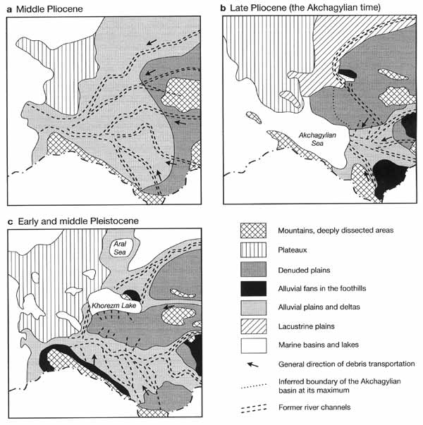
Fig. 2.6 Paleogeography of the Central Asian plains in the Pliocene and
Pleistocene. After Gorelov et al. (1989)
A complicated system of ancient Tertiary valleys exists in Central Kazakhstan where
more than three generations of valleys were identified (Svarichevskaya and Kushev, 1975).
A relatively high moisture supply was also typical of the Eopleistocene and the
presence of water bodies in many depressions, which had been filled during the
Akchagylian. One such lake existed in the Sarykamysh basin. It possibly received water
from the Amudarya and was about 70-80 m above mean sea level (a.s.l.). Another lake was
formed by the Syrdarya in the Mynbulak depression in the Kyzylkum. It has been established
that isolated enclosed lakes existed in the deepest western trough of the Aral basin (Kes
et al., 1993).
The Pleistocene was marked by progressive aridization, which eliminated the perennial
streams on the plains of Central Asia, and glaciers became the only source of runoff. The
Amudarya (which was flowing westwards), Murgab, and Tedjen brought and deposited large
volumes of sediment on the plain which accounted for the instability and frequent
migrations of the channels. Fedorovich (1975) suggested that in the early Pleistocene a
distributary of the Amudarya deviated to the north and flowed into the Sarykamysh basin
through the Upper Uzboy. Other rivers, originating in the mountains, discharged into
lakes, which were either long-term or periodically reappearing features. The Amudarya
turned northward towards the Aral Sea at the end of the middle to the beginning of the
late Pleistocene. This can be at least partly attributed to the fact that its former
channel was completely blocked by alluvium (Markov, 1965). During the early and middle
Pleistocene, the Syrdarya migrated across the northern Kyzulkum west of its modern
channel. During the Khazar transgression of the Caspian Sea, presumably marked by higher
rainfall, the river formed extensive though shallow lakes centred at about 46°N, 68°W
where the Chu and the Sarysu rivers joined it.
In the late Pleistocene and the Holocene, the Amudarya valley was stable in the middle
course while in the lower reaches it was constantly migrating. The river mouth moved from
the Aral basin to the Sarykamysh and back. As a result, three deltas were formed: the
first, located east of the present mouth, the second at the Sarykamysh, and a third
between both. When the river discharged into the Sarykamysh, the lake overflowed and the
water surplus discharged through the Uzboy (Fedorovich, 1975; Kes et al, 1993). The
Amudarya repeatedly emptied into the Sarykamysh, the last such event being about 800 years
ago.
<<< The Evolution of River Valleys in the
Quaternary | Physical Geography Index | Closed Inland Basins >>>
|


