Please put an active hyperlink to our site (www.rusnature.info) when you copy the materials from this page
Physical Geography of Northern Eurasia
Climatic Change and the Development of Landscapes
<<< History of Vegetation | Physical Geography Index | Synthesis: The
Development of a Zonal Structure in Modern Landscapes >>>
Cenozoic Climates: The General Trend
The Paleogene (65-24 Ma BP)
At the beginning of the Paleogene, climate was still as warm or warmer than in the late
Cretaceous. Analysis of vegetation has shown that continentality of climate increased
eastwards. The decrease in rainfall was particularly strong. Kazakhstan and Central Asia
had the highest heat supply with the paratropical landscapes developing between the
eastern Caspian and the Aral regions since the very beginning of the period.
After a cooler phase at the very end of the Paleocene and early Eocene, heat and
moisture supply began to rise conspicuously and the highest level in the whole Cenozoic
was attained at the time of the Eocene climatic optimum dated to about 53-50 Ma BP (Figure
2.12). The Eocene optimum featured not only a high global temperature (6°C above the
modern one), but also equable climatic conditions all over Northern Eurasia with the
temperature difference between the northernmost and southernmost regions being less than
10°C (Velichko et al, 1995). The highest temperatures occurred in the south-west of the
East European plain where mean annual temperature was about 27°C and annual rainfall
exceeded 1000 mm.
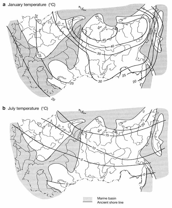
Fig. 2.12 Reconstructed climatic characteristics of the Eocene optimum
expressed as deviations from modern values. Modified from Velichko et al. (1995)
The Eocene optimum marked the end of the preglacial stage of the Cenozoic. A gradual
decrease in temperature began, with fluctuations superimposed on the general trend,
opening the stage of progressive cooling of the landscapesphere. This new stage featured a
few optima. However, they did not reach the level of the Eocene optimum and each
subsequent optimum was cooler than the previous one.
The second half of the Eocene and the early Oligocene were marked by a considerable
decrease in global heat supply. As a result, temperatures in high latitudes dropped by
10-12°C and the first alpine glaciers developed in the Antarctic at the Eocene-Oligocene
boundary (c. 38 Ma BP). A distinct cooling during the first half of the Oligocene has been
recorded in the south-west of the East European plain (where it occurred during the marine
transgressions and, therefore, did not feature abrupt fluctuations in temperature), in
Siberia, Kazakhstan, and Central Asia. Apart from the decrease in temperatures of 8-10°C,
annual rainfall decreased by 200 mm to 600 mm in Kazakhstan and Central Asia.
The Neogene (24.6-1.6 Ma BP)
The Neogene, including its first and longest Miocene stage (24.6-5.1 Ma BP), featured
frequent climatic and landscape changes. Thus, despite general cooling, a distinct warming
occurred about 21-20 Ma BP, as indicated by the presence of subtropical elements in
floras, and another one occurred in the late Miocene about 11.3-10.3 Ma BP. Both optima
were well expressed on the East European plain (winter temperatures in the southern
regions attained 8-10°C) and in Western Siberia where the first Miocene optimum was most
pronounced.
Later phases of the Miocene (beginning approximately from 9 Ma BP) were marked by a
cooler climate and the progressive increase in aridity, especially in southern Western
Siberia, where steppes, a new zonal component, developed. In the southernmost region,
around Lake Balkhash, annual rainfall did not exceed 300 mm. These processes peaked about
6-5.5 Ma BP synchronously with the Messinian crisis. A cold temperate climate established
across most of Northern Eurasia.
During the first half of the Pliocene, the heat supply increased. In the south of the
East European plain, winter temperatures gradually rose to 2-4°C as indicated by the
presence of broad-leaved species in pollen spectra. In Western Siberia, cooling continued
longer and the January temperatures were below -24°C until 4.9-4.4 Ma BP. Later they
increased to 0-4°C at 56-57°N along with the increase in aridity as indicated by the
dominance of dry steppe and desert vegetation associations. The occurrence of forests with
a few broad-leaved species on the coastal plains of north-eastern Asia indicates that the
region had a temperate humid climate. The period between 4.2 and 4.0 Ma BP is considered
as the Pliocene climatic optimum.
The second half of the Pliocene was characterized by climatic fluctuations at a lower
thermal level and increasing aridity particularly during cooler episodes. Strong cooling
of the middle Akchagylian, marked by a vast transgression of the Caspian Sea, presumably
corresponded to the pre-Tiglian in Western Europe (2.7-2.1 Ma BP) and the onset of
glaciation in Scandinavia (Velichko, 1973). Data on paleoflora in the south-west of the
East European plain indicate that the January temperatures were as low as -10°C (Grichuk,
1981). Progressive cooling also occurred in Siberia where the January temperatures
decreased to 16-18°C below zero and permafrost developed for the first time across the
north-eastern regions.
On the whole, the Pliocene was characterized by more frequent climatic fluctuations
than the previous intervals and by restructuring of the landscape systems.
Climatic cooling became stronger, especially after the Pliocene optimum which was the
last one and had the lowest thermal level of the principal Cenozoic optima. Data for East
European and West Siberian plains (the occurrence of forests of temperate-subtropical
character in the west and dry steppes and semi-deserts in the east) indicate a sharp
increase in continentality and aridity of climate eastwards. While the Miocene climates
and landscapes may be considered as precursors of modern climates and landscapes, it was
during the Pliocene that all the principal components of landscape developed, including
the cryogenic phenomena.
The Quaternary
The Quaternary is subdivided into the Eopleistocene, Pleistocene, and Holocene. The
Eopleistocene was the longest interval (1.6-0.7 Ma BP), yet climatic fluctuations were
much less frequent than in the Pleistocene. Its characteristics are intermediate between
the Pliocene and the Pleistocene.
The well-studied sedimentary sequences in the southwest of the East European plain have
revealed that at least two warm epochs, marked by high heat and moisture supply similar to
those of the subtropics, occurred. Forest communities on red soils prevailed. The dry
steppe landscapes, where loess material sedimentation occurred under the extremely arid
conditions, were typical of the cold epochs in the south of the East European plain. A
similar cryoarid stage with winter temperatures of about -30°C has been reconstructed for
Western Siberia, although its correlation with the cold stages of the East European plain
has not yet been fully established. Aridity could partly have resulted from sea ice
formation in the Atlantic which blocked the principal source of moisture supply to the
continental regions. Further east, in the Lena basin and in north-eastern Asia, sections
dated to the Eopleistocene contain several generations of ice wedge polygons which
indicate several cold intervals with a mean annual air temperature of about -5°C. Phases
of cryogenesis alternated with much warmer intervals when permafrost degraded.
The Eopleistocene marked the beginning of a new phase in climatic and environmental
dynamics in Northern Eurasia. Cold stages featured strong aridity and continentality which
favoured the development of open landscapes even in the south of the East European plain
and Western Siberia. In north-eastern Asia, increasing aridity was accompanied by the
expansion of permafrost. The cold stages, distinguished by strongly continental climate,
were succeeded by periods of higher heat and moisture supply when environments were not
unlike those of the Pliocene (Velichko, 1981)
The Pleistocene sequences have been studied most thoroughly on the East European plain,
and most of the discussed reconstructions are based on the data from this region.
Four climatic microcycles, consisting of four warm and four cold stages, occurred in
the lower Pleistocene (700-400 Ka BP), which corresponds to the Cromerian in the West
European schemes (Table 2.1). Analysis of vegetation has shown that the earlier warm
epochs were almost as mild as those in the Eopleistocene. For example, in the south of the
East European plain, the January temperatures exceeded 5°C (although in the north they
were as low as -4°C) and the July temperature approached 25°C. Annual rainfall ranged
between 600 mm and 800 mm. Throughout the lower Pleistocene,. Siberia had a continental
climate characterized by greater seasonal variability. During the first warm phase,
temperatures varied between -15°C and -18°C in January and reached 18°C in July. A mild
monsoon climate existed in the Far East, with high rainfall (about 800 mm) and the winter
temperature decreased from -2°C or -3°C at the beginning of the interval to -16°C at
the end.
The middle Pleistocene began with an interglacial interval, known as the Likhvin in
Eastern Europe and Tobolsk in Siberia, which has been studied in considerable detail.
During its optimum, the winter temperatures were below zero (-2°C — -5°C) in the north
of the East European plain and reached 1°C in the south, while the July temperatures
ranged between 18°C and 24°C. In Western Siberia, the January temperatures were between
-11°C and -13°C, while in July they did not exceed 18°C. In the north-east of the
continent, even during the warm phases, mean annual temperatures remained negative. This
accounts for the development of permafrost, which has remained in the region ever since.
Climatic fluctuations gained their maximum range during the late Pleistocene. This
interval began with the Mikulino-Kazantsevo interglacial which was marked by the rise of
global temperatures by about 2°C above modern values. In Northern Eurasia, thermal
regimes strongly varied spatially (Figure 2.13).
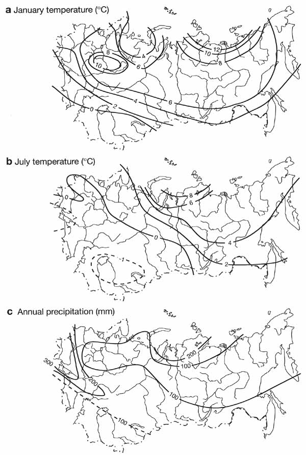
Fig. 2.13 Reconstructed climatic characteristics of the late Pleistocene
interglacial optimum expressed as deviations from modern values. Modified from Velichko et
al. (1995)
The January temperatures, for example, were slightly negative in the south of the East
European plain, while in the north they were between -4°C and -6°C. In Western Siberia,
winter temperatures were much lower: between -18°C and -20°C in the north and -12°C and
-15°C in the south. The most pronounced deviations from the modern values (about +8°C to
+12°C in winter and +6°C to +8°C in summer) have been reconstructed for the north of
Western and Central Siberia. Warming was presumably accompanied by an increase in
rainfall. In Central Asia and Kazakhstan, the interglacial optimum corresponded to the
late Khazarian transgression of the Caspian Sea which was synchronous with the Boreal
transgression of the northern seas (Table 2.1). There is evidence of a strong (8-10 m)
rise in sea level and higher (up to 1000 mm) rainfall in the Far East.
The subsequent cold epoch included the climatic minimum of the Pleistocene during which
temperature decreased across the continent and the periglacial zone expanded greatly. Even
in the south-west of the East European plain, where climate was usually mild, mean
temperatures decreased to -30°C in winter and to about 16°C in summer. A distinct
climatic minimum has been recorded in the monsoon regions of the Far East where the mean
annual temperature dropped by almost 10°C and rainfall decreased to 400-500 mm. The late
glacial stage was marked by a series of sharp fluctuations which occurred against the
background of climatic warming, whose range gradually became smaller towards the
post-glacial Holocene optimum.
A warming of an interglacial type, which occurred in the Holocene, also proceeded as a
sequence of warmer and colder phases. Paleobotanical data suggest that the first
conspicuous shift towards warmer conditions occurred in the Boreal (9-8 Ka BP). However,
this warm phase was not the major one in the majority of high and mid-latitude regions.
Only a few regions featured temperatures similar to the modern ones. The principal warming
occurred in the late Atlantic (5500-5000 years BP) and was marked by a 3-4°C rise in both
winter and summer temperatures. The mean global temperature was about 1°C above the
modern one (Figure 2.14). Climatic cooling has been the principal trend between the
Holocene optimum and the present time, although a few warmer phases have been identified
(e.g., the Subboreal between 4000 and 3500 years BP and the medieval climatic optimum in
the llth and 12th centuries).
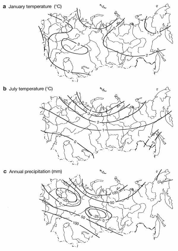
Fig. 2.14 Reconstructed climatic characteristics of the Holocene optimum
expressed as deviations from modern values. Modified from Velichko et al. (1995)
<<< History of Vegetation | Physical Geography Index | Synthesis: The
Development of a Zonal Structure in Modern Landscapes >>>
|


