Please put an active hyperlink to our site (www.rusnature.info) when you copy the materials from this page
Physical Geography of Northern Eurasia
Climatic Change and the Development of Landscapes
<<< Cenozoic Climates: The General Trend
| Physical Geography Index | Climate at
Present and in the Historical Past >>>
Synthesis: The Development of a Zonal Structure in Modern
Landscapes
The evolution of climates and landscapes of Northern Eurasia was marked by an extremely
wide range of transformations in the Cenozoic. The range of climatic and landscape changes
recorded during the last 60 Ma was the largest in the landscapesphere history of the
planet. These transformations were mainly controlled by global changes in heat balance
although the state of the Earth's surface also influenced the global climate system.
The character of climatic fluctuations changed through time. At the higher thermal
level of the early Cenozoic, the climate system experienced long-period fluctuations (5-10
Ma) with an amplitude of 2-4°C (Velichko, 1989). The end of this interval was marked by
the Eocene optimum, the principal thermal maximum of the Cenozoic. Between the end of the
Eocene and the Pliocene, the frequency of the oscillations increased, their period reduced
to 1-5 Ma, and the amplitude of mean annual temperatures increased (Figure 2.15).
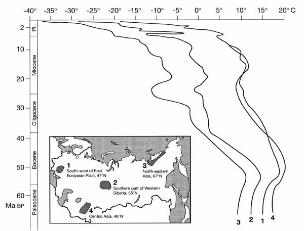
Fig. 2.15 Mean January temperatures in the Cenozoic in four regions of
Northern Eurasia. Compiled by A. Velichko and V. Nechaev
About 1 Ma BP, climatic changes became more regular and quasi-cyclic in character. The
alternating glacial and interglacial phases formed macrocycles. The duration of each
macrocycle varied between 200 Ka to 100 Ka, decreasing progressively. Temperature also
decreased from the earlier macrocycles towards the later ones. Thus temperature during an
optimum of each of the three best expressed interglacials, which occurred in the last half
a million years, was about 1°C lower than the temperature of the previous optimum. The
same tendency for an increasing severity of climate has been observed during the glacial
phases. For example, while only ground veins developed in the central East European plain
during the cold phases of the early Pleistocene, ice wedges formed in the second half of
the middle Pleistocene. This is a weighty evidence of permafrost existence (Nechaev,
1996). The maximum expansion and the lowest temperature of permafrost occurred during the
cold phases of the late Pleistocene.
Temperature changes in time, therefore, show a certain regularity: slow and rather
smooth 'long-wave' oscillations were typical of the early Cenozoic; 'middle-wave'
rhythmical fluctuations with growing amplitude occurred in the Neogene; and high frequency
cyclic fluctuations developed in the Pleistocene. As thermal levels were in general
declining, fluctuations became more pronounced and more clearly recorded in sediments
(Sinitsyn, 1980b). The colder the climate became, the stronger the effect its fluctuations
(even the small ones) had on landscapes, especially in higher latitudes, where changes in
mean annual temperature by 2-4°C induced considerable shifts in zonal boundaries. High
frequency oscillations at a lower thermal level were amplified by positive feedbacks such
as the ice-albedo feedback (Velichko, 1973). The decrease in the mean global temperature
was accompanied by an increase in the equator-pole temperature difference, which changed
from 10-12°C at the beginning of the Cenozoic to 40-42°C in the Holocene.
Within the framework of the Meso-Cenozoic megacycle, the modern stage is a cold stage
of the late Cenozoic and a warm (interglacial) phase of the latest Holocene macrocycle.
The interglacial began at 10.3 Ka BP and its optimum occurred at 6-5.5 Ka BP. The present
time, therefore, belongs to the second half of the interglacial and is characterized by
climatic cooling.
Climatic change controlled the development of the zonal structure (Figure 2.16). For a
long time, Northern Eurasia was a single vast forest zone (or hyperzone). The internal
structure of this zone changed in time.
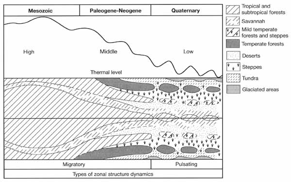
Fig. 2.16 Schematic representation of the dynamics of latitudinal
zonality during the Mesozoic and Cenozoic. After Velichko (1989)
Throughout the Paleocene and the first half of the Eocene, subtropical evergreen
forests covered western and southern Eurasia and had a high proportion of tropical
elements in the south of Central Asia (paratropical sub-zone). The northern part of the
continent was occupied by the mild temperate forests with abundant subtropical plants. The
impoverished subtropical forests survived in the south through the late Eocene and
Oligocene. The mild temperate forests still remained in the mid-latitudes and in
Kazakhstan and Central Asia. In the forests of Western Siberia, small- and broad-leaved
species coexisted, while in higher latitudes mixed broad-leaved coniferous forests
developed for the first time. Later, temperate mixed forests expanded southwards. By the
middle of the Miocene, savannah-like landscapes had developed in Kazakhstan, and later in
the south of the East European plain and Western Siberia. A completely new zonal component
— steppes — developed at the end of the Miocene. In the Pliocene, the tundra biome
formed in response to further cooling. Semi-deserts and deserts developed as a result of
increasing aridity.
These conclusions are in good agreement with a previously developed concept of
planetary zonal pattern evolution (Velichko, 1989) which suggested that in the Paleogene
and Neogene a monozonal (or hyperzonal) structure was replaced by a polyzonal one. Until
the late Pliocene, changes in zonal structure were 'migratory' (i.e., changes referred to
shifts of zonal boundaries).
The dynamics of biomes in the Quaternary were different. A new type of hyperzone, the
cryohyperzone, dominated by open landscapes (such as periglacial steppes, tundra and dry
steppes) developed in response to the severe climates of glacial epochs, while the forest
zone became much smaller. During the warm phases, a polyzonal structure, in particular the
forest zone, was restored. Such a regime of alternating polyzonal and cryohyperzonal
structures may be described as a 'transformational' or 'pulsating' type of zonal dynamics.
Although a polyzonal structure was restored during every interglacial, zonal plant
communities were different from those of the previous warm phases. Similarly, landscape
zones were not restored precisely at the same positions. For example, tundra almost
disappeared during the earlier interglacials, only surviving as a narrow strip along the
Arctic coast in the Holocene. The type of the modern polyzonal system is that of a cooling
of the post-optimal stage of an interglacial. This system includes elements of very
different ages. Thus tundra communities developed in the Eopleistocene whereas steppe
communities date back to the Miocene. In other words, the modern zonal structure is
heterochronous.
Longitudinal differentiation of biocoenoses developed with time. It was very poorly
expressed in the early Cenozoic when subtropical forests covered both the East European
plain and Siberia. Since the late Oligocene, and especially in the middle Miocene,
landscapes became more differentiated. Thus landscapes of north-eastern Asia became well
adapted to cooling and later to increasing aridity. Climatic change in this region could
be forced by neotectonic uplifts: the newly forming mountains prevented the transportation
of relatively warm and moist air by the westerlies (Sinitsyn, 1965). However, the
formation of a topographic barrier was not the only factor. Under conditions of
progressive planetary cooling, a high pressure system (the Siberian anticyclone) developed
over the mountains and became one of the most important atmospheric centres. With mountain
building, its cooling influence spread further westwards and contributed to the formation
of sea ice in the Arctic. Another high montane system, the Himalayas-Tibet, formed at the
same time with another anticyclone of global importance being related to it (Li, 1991).
A radical alteration took place in the atmospheric circulation and climatic system of
Northern Eurasia in the Cenozoic. Throughout most of the Paleogene, westerlies were of
primary importance under the conditions of high heat supply and subdued topography. In the
Neogene (in particular, since the middle Miocene) and Quaternary, active orogenesis, which
occurred in the south and east of the region, significantly changed the atmospheric
circulation. It may be concluded, therefore, that the modern climatic system began to form
about 15 Ma BP and became similar to the modern one ,in the Pleistocene.
Modern landscapes, the landscapesphere as a whole, and individual landscape units
combine components of different age. First, there are considerable differences in the ages
of the biotic and abiotic components. Plant communities are the youngest and respond to
changes most quickly. They are different from those of the Holocene optimum. At present,
they adapt to general cooling. Soils are more conservative and some soil profiles
integrate processes of the whole Holocene history. Abiotic components are older as a rule
and may bear imprints of ancient events. Thus, in the formerly glaciated regions, strong
differences between the types of the surface exist, the morainic relief being the youngest
type within the limits of the latest Pleistocene ice sheet expansion. Rather young are the
subsurface deposits in the loess regions where loess accumulation terminated just before
the Holocene. However, the late Pleistocene permafrost impacted surface topography: the
relict cryogenic microrelief remained after the ice wedges melted in late glacial time.
The microrelief, in turn, affects the development of soils and erosion at present.
To conclude, a typical feature of modern landscapes and landscapesphere is
heterogeneity and many of their properties and components have been inherited from the
past.
<<< Cenozoic Climates: The General Trend
| Physical Geography Index | Climate at
Present and in the Historical Past >>>
|


