Please put an active hyperlink to our site (www.rusnature.info) when you copy the materials from this page
Physical Geography of Northern Eurasia
Climate at Present and in the Historical Past
<<< Climate at Present and in the Historical
Past | Physical Geography Index | Climate
Regionalization and Air Mass Climatology >>>
General Atmospheric Circulation
The general atmospheric circulation over Northern Eurasia is relatively simple because
of its landlocked position. However, surface pressure patterns vary strongly between
winter and summer and winter weather patterns can be complex in the European territory and
Western Siberia.
In winter, a high pressure system, known as the Siberian or Asiatic high, develops in
response to strong radiational cooling of the earth surface (Figure 3.1 a).
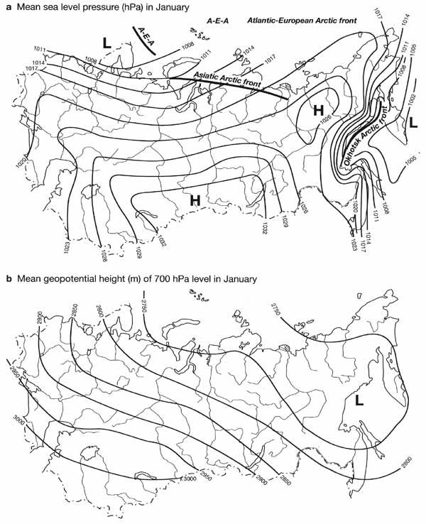
Fig. 3.1 Mean sea level pressure and geopotential height of 700 hPa
level in January. Modified from Lydolf (1977)
The Siberian high is a semipermanent centre of action dominating Eastern and Central
Siberia and Kazakhstan between November and March. Its main centre is positioned over
90-110°E and 40-55°N extending to the north-east where a secondary centre develops over
the Yana-Indigirka-Kolyma basins (Sahsamanoglou et al., 1991). The extension of the
Siberian high to the east is limited by the Pacific Ocean but it often extends westwards
to Europe and south-westwards to the Middle East. Being thermally induced, the Siberian
high is a shallow system confined to the lowest 1.5 km of the atmosphere. Already at a
height of 850 hPa, high pressure is replaced by a trough extending from the Barents Sea
south-eastwards and linking the Icelandic low in the north-west and the Aleutian low in
the north-east (Figure 3.1b). The Icelandic low exerts a strong influence on winter
weather in the European territory, Western Siberia and northern Central Siberia as
depressions, which affect these parts of Northern Eurasia, originate mostly in the North
Atlantic. In the European territory, westerly and south-westerly flows dominate in winter
and intense depression activity predetermines higher temperatures, cloudiness (which, in
turn, counteracts the radiative loss of heat) and precipitation than in the east.
South-westerly flow, developing on the peripheries of the Icelandic depression and the
Siberian high, dominates over Western Siberia, bringing in air masses either from the
European territory or from Kazakhstan and Central Asia. However, when the Siberian high
extends to Europe, it effectively blocks the zonal flow and eastward propagation of the
Atlantic depressions, displacing their track northwards towards the Arctic Seas.
Similarly, depressions originating over the Mediterranean, which usually travel over the
southern East European plain to Western Siberia, are forced to deviate southwards to the
mountainous regions of Central Asia.
The cyclonic activity takes place on the Arctic and Polar fronts. The Arctic front
extends along the northern shore of Eurasia (Figure 3.1 a). The Arctic Seas (with the
exception of the Barents Sea) remain frozen between October and June and climatically pack
ice acts almost as a land mass. Although heat is transmitted through sea ice, it is
quickly lost under the clear-sky conditions and during the polar night the radiation
budget in the central Arctic Ocean is negative (about -2 kcal cm-2 month-1) and very close
to the radiation budget of the Eurasian land mass (Barry and Hare, 1974). However, over
the Barents Sea, which is affected by the North Atlantic Drift, and over the offshore
areas of weak ice in the Siberian Seas temperatures are higher than over land and a strong
temperature gradient exists between the sea and the continent (see below for a further
discussion of sea ice conditions). Depressions, originating in the Icelandic low,
regenerate over the relatively warm Barents Sea (the area of most intense cyclogenesis and
rejuvenation of depressions in Eurasia) and continue along the Arctic front as far as the
Taymyr peninsula bringing milder weather to Central Siberia. The positions of the Arctic
front show a great range of day-to-day fluctuations and it is not unusual for the arctic
air to reach the Black and the Caspian Seas or even the foothills of the Central Asian
mountains. The Polar front is generally positioned south of FSU territory. However,
depressions, originating over the Mediterranean and the Middle East and rejuvenating over
the Black Sea and the Caspian, penetrate into the European territory and Central Asia
causing migrations of the Polar front northwards. Therefore, while the general circulation
over Eurasia is relatively simple, the two-front system predetermines a great complexity
of winter weather over the European territory and Western Siberia.
The winter circulation reaches its peak in February. Towards the beginning and the end
of the cold season, the intensity and extent of the Siberian high vary and it is often
characterized by the development of multiple centres. In April, the Siberian high weakens
and its centre shifts westwards to north-eastern Kazakhstan. As the Siberian high
dissipates, low pressure develops over Eastern Siberia and the Far East. In the west, an
extension of the Azores high builds up. In summer, a weak low pressure zone dominates over
most of the Asiatic part while the European part is dominated by the Azores anticyclone
(Figure 3.2).
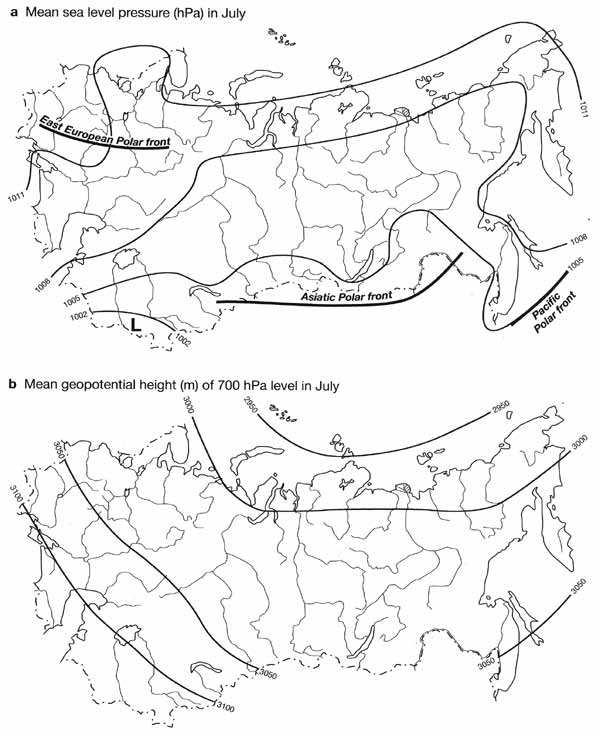
Fig. 3.2 Mean sea level pressure and geopotential height of 700 hPa
level in July. Modified from Lydolf (1977)
Both Icelandic and Aleutian lows weaken and a shallow high pressure system develops
over the Arctic. High pressure ridges, propagating eastwards, and the Arctic anticyclones,
moving from north to south, maintain the extension of the Azores high. The Arctic front
migrates far to the north and only occasionally does it return to the continent, reaching
as far south as the forest zone. The depression activity is associated with the Polar
front which migrates into the European territory and to the Siberian-Mongolian border.
Soil moisture is high across the forest zone where evaporation occurs at a substantial
portion of its potential rate. The Eurasian forests are almost as effective in supplying
water vapour to the atmosphere as the oceans and the Atlantic depressions are known to
bring precipitation as far eastwards as Lake Baikal. By contrast, the Polar front, which
does affect the mountains and foothills of Central Asia in spring, dies out over the
deserts in summer.
The origin of the mid-latitude aridity has been given much attention in recent years.
While the existence of subtropical deserts received dynamical explanation long ago, the
development of mid-latitude deserts, which stretch from the shores of the Caspian Sea to
northeastern China, has been traditionally attributed to the enormous distance from
oceanic sources of moisture enhanced locally by the presence of high mountains blocking
the entrance of humid maritime air masses (Trewartha and Horn, 1980). However, students of
paleoclimates know that the onset of desert expansion in Eurasia coincided with the uplift
of the mountains which now extend along its southern rim (see below). The evidence from
the past suggests that it is orography that exerts the primary control over the
large-scale atmospheric circulation and precipitation in the middle latitudes (although
the role of contemporaneous changes in the distribution of continents and global Cenozoic
cooling should not be disregarded). This evidence, suggesting a connection between
orography and the distribution of the Eurasian mid-latitude arid climates, has been
corroborated by climatic modeling which simulated Eurasian climate with and without
mountains (Manabe and Broccoli, 1990, 1992).
Precipitation in the middle latitudes is associated with atmospheric depressions
propagating along the Polar front. The preferred position for the development of
depressions is controlled by the position of stationary planetary waves in the upper
atmosphere. Depression activity is strongest and precipitation is heaviest downstream of
the stationary wave troughs, in the area of large-scale ascent of the air. By contrast,
upstream of the troughs, in the area of large-scale descent, synoptic activity is weak and
precipitation is light. The position of the stationary waves and their amplitude are, in
turn, determined by the distribution of the oceans, continents and large mountainous
barriers. The mountains of interior Asia, and particularly the Tibetan plateau, split the
upper-air westerly flow into two jets. One jet is displaced southwards and flows over
northern India; another one is displaced northwards and flows over northern China. This
displacement induces the position of stationary waves in such a way that an upper-air
trough is associated with the Tibetan plateau. Large-scale subsidence and weak depression
activity occur upstream of this trough, over Central Asia, while ascent and frequent
development of storms occur downstream. During summer, upper westerlies retreat further
north where they are affected by the relatively low mountains. Although the westerlies do
not impinge on the Tibetan plateau, the plateau still exerts its influence on the climate
of Central Asia via the remote influence of the Asian monsoon. The intense heating of the
surface results in the formation of a thermal low centred over the south-eastern part of
the Tibetan plateau. Associated with this low is a circulation extending from east to
west. Intense ascent, aided by the release of latent heat, occurs over the south-eastern
slopes of the plateau where large volumes of air, rising from the surface, are matched by
the outflow in the upper atmosphere. The outflow of air gives rise to a jet which flows
eastwards and subsides. The overturning of the monsoon circulation is discussed in many
texts on tropical climatology (e.g., McGregor and Nieuwolt, 1998). It is the localization
of the descent that is important for the development of deserts. The Kyzylkum and Karakum
deserts of Central Asia are one of the centres of descent. Thus the adiabatic subsidence
of air flowing out of the monsoon region appears to be a factor responsible for low
precipitation in Central Asia. However, recent modelling studies by Rodwell and Hoskins
(1996) have shown that the descent mechanism does not represent a simple monsoon
overturning. The observed and modelled descent is a result of the interaction between the
monsoon heating and the southern flank of the mid-latitude westerlies (monsoon heating
enhances subsidence of the westerly flow) and orographically induced anticyclonic
circulation (which localizes the area of descent). The combined effect of these factors is
adiabatic warming of descending air, reduction in specific humidity, lack of convection
and clouds. However, modelling shows that the adiabatic descent is not sufficient to
generate the observed aridity by itself but it initiates radiative cooling in the
cloud-free atmosphere which intensifies the descent further. Therefore, the aridity of
Central Asia originates from the combination of circulation and radiative factors.
Directly affected by the East Asian monsoon is the Russian Far East were seasonal
reversals of atmospheric flow occur along the Pacific coast. In winter, cold air moves out
of the area dominated by the Siberian high in a southerly direction towards Japan and
mainland Southeast Asia. In summer, the subtropical high in the Western Pacific expands
northwards and south-easterly flow emanates from its flanks. An important feature of the
summer monsoon in the Russian Pacific is a distinction between precipitation regimes in
the early and late summer. In spring and early summer, a localized area of high pressure
develops over the cold Sea of Okhotsk where floating ice remains until midsummer and the
southern Far East is affected by the relatively cold and dry air which provides little
rain. The summer monsoon does not reach its full extent until the second half of summer
and early autumn (see below).
<<< Climate at Present and in the Historical
Past | Physical Geography Index | Climate
Regionalization and Air Mass Climatology >>>
|


