Please put an active hyperlink to our site (www.rusnature.info) when you copy the materials from this page
Physical Geography of Northern Eurasia
Soils of Northern Eurasia
<<< Autonomous and Heteronomous Semi-humid
and Semi-arid Soils | Physical Geography Index | Azonal Soils >>>
Autonomous and Heteronomous Arid Soils
Soils of the southern steppes, semi-deserts, and deserts constitute a group of arid
soils. The autonomous soils of this group include calcic chernozems, chestnut soils, and
calcisols. Solonchaks and solonetz are heteronomic soils.
Soils of Steppes
The steppes of Northern Eurasia occupy vast areas. They include forest-steppes with
automorphic chernozems (luvic, leached, and typical), typical steppes with common and
southern chernozems, and southern steppes with chestnut soils. Meadow chernozems and
meadow chestnut soils cover considerable areas among heteronomous soils.
Chernozems are the most fertile and therefore the most used soils. They represent about
half of all the agricultural soils of Northern Eurasia and are used for growing grain,
oil-bearing plants, and fruit crops. The best pastures are also supported by chernozems.
Chernozems occupy about 1.9 million km2 or 8.6 per cent of the total area of
the FSU (Krupenikov, 1967; Rozov, 1968; Chernozemy SSSR, 1974; Simakova et al, 1996). They
extend from the Danube delta to the southern Altay and occur locally in the intermontane
depressions of the Greater Khingan mountains (Figure 4.4).
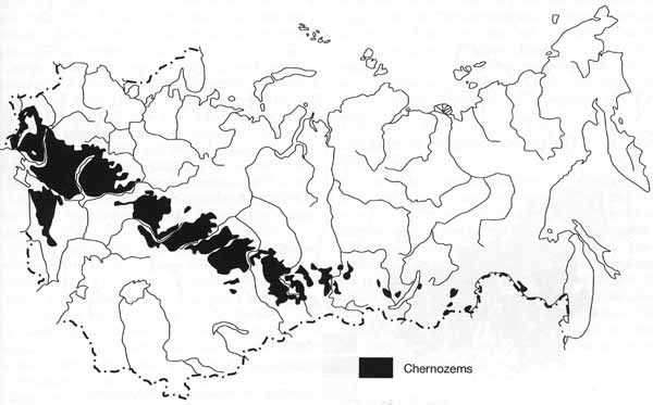
Fig. 4.4 Distribution of chernozems
Chernozems develop on lowlands or rolling plains with loess and loess-like loams and
seldom on clays. Parent rocks usually contain carbonates and, in Western Siberia and
Kazakhstan, easily soluble salts.
Calcic chernozems are formed on carbonate loess-like loams (Figure 4.1).
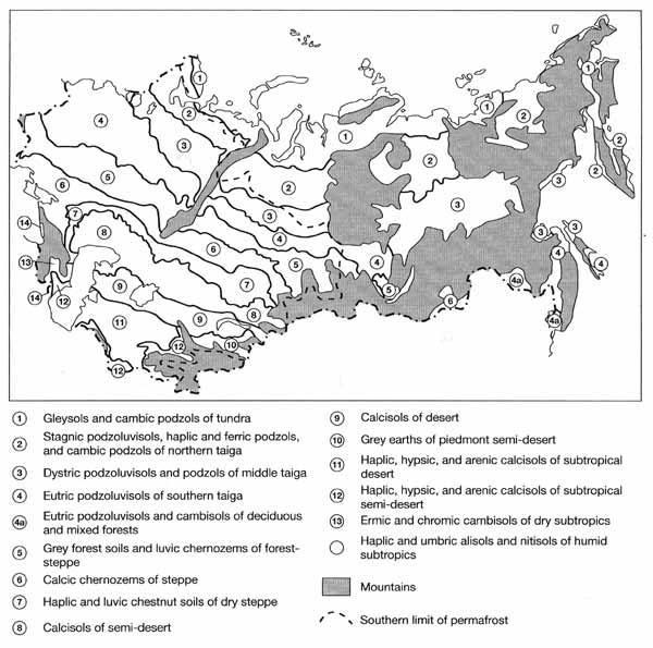
Fig. 4.1 Types of soils and corresponding vegetation zones in Northern
Eurasia
They exhibit the most typical features of chernozem formation, such as intensive humus
accumulation, limited carbonate leaching, absence of eluvial-illuvial differentiation of
the soil profile by clay fraction, iron and aluminium, complete saturation by bases, and a
weak alkaline reaction of the soil solution (Plate 4.2).
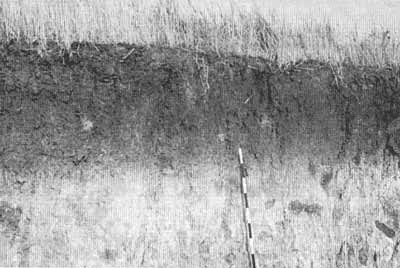
Plate 4.2 Chernozem soil. The dark colour in the upper horizon is due to
the accumulation of humus
(photo: courtesy of Professor A. Aleksandrovsky, The Dokuchaev Soil Institute, Russian
Academy of Science, Moscow)
Chernozems have a high CEC, especially in the humic horizon, reaching 50 milli
equivalents for 100 g soil. Calcium is dominant among the absorbed bases.
In the chernozem zone, meadow chernozems develop in poorly drained localities, such as
the lower parts of slopes, depressions, and ravines. They also develop under conditions of
moisture surplus in northern steppes and deciduous forests. Meadow chernozems are very
similar to chernozems in their morphology, but are distinguished by their darker colour
and prolixity of humic horizon, increased humus contents, and presence of gley in the
lower horizons.
Chestnut soils occupy 107 million hectares or 4.8 per cent of the total area of the FSU
and support grain crops (Rozov, 1968; Simakova et al., 1996). They develop on lowlands,
rolling plains, and hilly terrain in Kazakhstan (Figure 4.5).
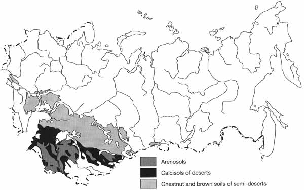
Fig. 4.5 Types of soils in arid regions
Soil-forming deposits are represented by carbonaceous loess-like loams, loess, salted
loams, and clays and by weathering products of sandstones, limestones, and mergels. The
profile of chestnut soil is not differentiated by clay fraction, silica acid, and
sesquioxides contents. These soils always have carbonates immediately beneath the humic
horizon. They often accumulate gypsum and easily soluble salts at a depth of 1.0-1.5 m.
The soil-absorbing complex is saturated by calcium and magnesium cations, and their
reaction is neutral or weakly alkaline across the profile.
In river valleys and terraces and intermountain depressions, where moisture is abundant
and vegetation is represented by herbs and grasses, meadow chestnut soils develop. These
soils have a thicker humic horizon and increased humus contents in comparison with the
automorphous chestnut soils. These are one of the best agricultural soils in the chestnut
soil zone.
Solonetz, which are representative of the heteronomic group, are saline soils
containing easily soluble salts harmful to plants. Salts occur at a depth of 20-50 cm and
contain a considerable amount of exchangeable sodium in the soil absorption complex
(Kovda, 1946, 1947; Zasolennye, 1973; Pankova and Novikova, 1996). They develop in
topographic lows, such as depressions on floodplains and interhill valleys, under
conditions of increased surface moisture supply or the presence of ground water with
various degrees of mineralization. A solonetz profile is differentiated by its
eluvial-illuvial type. Sodium constitutes over 15 per cent of the total exchangeable
cations in the illuvial horizon and easily soluble salts (sulphates, chlorides, gypsum,
and carbonates) are concentrated in the lower part of the profile. The horizon, which
develops above the solonetz horizon, is enriched by silica acid and is poor in
sesquioxides and clay fraction in comparison with the underlying horizons. The reaction of
the soil solution is alkaline in the lower part of the profile. Physical properties are
poor because of the high density and columnar structure of the illuvial horizon.
The Soils of Semi-deserts and Deserts
Semi-deserts and deserts occupy about 8 per cent of the FSU area, stretching from the
Caspian lowland to the Mongolian border (Lobova, 1960). The texture of parent materials
and the concentration of salts vary. Loess-like loams, salinized alluvial-lacustrine
deposits, older alluvial sand, and sandy-clay sediments occur on the flat Caspian lowland.
In the southern Urals, which has dissected and hilly terrain, parent rocks are limestones
and clay schists while in the Kazakh Knolls the parent material is loess-like carbonate
loams and salinized Tertiary rocks. On the Turgai upland, salinized heavy loams are
intermingled with sandy deposits. In deserts, parent rocks are older alluvial sandy
deposits and in the piedmonts desert-steppe loesses and loess-like loams, often underlain
by gravels, dominate. Alluvial loams and clays with gravel inclusions often occur there.
Soils of the arid zone can be defined as mostly accumulative, saturated, neutral-alkaline,
siallitic, carbonate, and/or salt xeromorphic soils.
Brown semi-desert soils (calcisols) and meadow brown soils dominate in the
desert-steppe zone, which covers about 2 per cent of the total soil area of the FSU
(Figures 4.1 and 4.5). They have some natural fertility but arable agriculture requires
irrigation. In deserts, grey-brown desert soils and takyrs (the clayey lands which are
flooded in spring and dry out and crack into polygonal sections in summer) dominate and
occupy 6.3 per cent of the total area (Figures 4.1 and 4.5). They have low natural
fertility and mainly support pasture.
The principal feature of calcisols is their low humus content and the small thickness
of their humic horizon (Lobova, 1960). Typical is the formation of the solonetz horizon.
The A horizon is poor in clay fraction, iron, and aluminium but is relatively enriched by
silica. Soils are mostly carbonate-enriched. However, they do not necessarily contain
gypsum and easily soluble salts in the lower part of the profile. Calcium and magnesium
are dominant among the exchangeable bases and the sodium content varies between 1 per cent
and 14 per cent of the absorption capacity.
Vast areas are occupied by sandy deserts: the sandy Karakum and Kyzylkum deserts cover
55 million hectares (Lobova, 1960). Soils termed 'arenosols' represent mainly
wind-redeposited sands or older alluvial deposits (Figure 4.5).
Takyrs are the soils of clay deserts. They are distributed in present river deltas,
older channels, piedmont plains, and intermontane depressions. These soils develop where
there is permanent water stagnation in endoreic depressions composed of loams and clays.
As a result of such conditions, salinization and desalinization processes have taken part
intermittently in the formation of the soil profiles.
Solonchaks are salinized soils in which easily soluble soils develop on the surface,
forming crusts or puffy horizons (Kovda, 1946, 1947; Zasolennye, 1974; Pankova and
Novikova, 1996). Solonchaks are formed when highly mineralized ground and soil waters
occur close to the surface at a depth of 0.5-3.0 m. They are usually associated with swamp
margins and salt lakes, the bottoms of dry lakes, and higher terraces. Solonchaks occur
mainly in deserts where they occupy about 10 per cent of the area. Apart from high salt
contents near the surface, the presence of gypsum and carbonates in the profile is typical
of solonchaks. The profile is distinguished by an absence of differentiation in the
contents of oxides and silicic acid, by grain-size distribution and mineral counts. The
chemical and physical properties of solonchaks depend on their salt chemistry (chloride,
chloride-sulphate, sulphate-chloride, and sulphate-sodium). Sodium solonchaks are
characterized by the poorest properties because the alkaline reaction causes the
peptization of colloids and compacting of the soil mass.
The Soils of Piedmont Desert and Steppe Zones
The piedmont desert and steppes in Central Asia and Transcaucasia accommodate grey
earths. The total area occupied by grey earths, meadow grey earths, and meadow soils of
the region is 33 million hectares or 1.5 per cent of the total area of the FSU (Rozov,
1968). In the mountains of Tien-Shan, Pamir, and Kopetdagh, the grey earth zone is the
lowest altitudinal belt. The typical parent rocks are loesses and loess-like loams often
underlain by gravels. Grey earths have a low humus content (1-4 per cent) and are rich in
carbonate. They do not contain any appreciable amounts of easily soluble salts and gypsum.
<<< Autonomous and Heteronomous Semi-humid
and Semi-arid Soils | Physical Geography Index | Azonal Soils >>>
|


