Please put an active hyperlink to our site (www.rusnature.info) when you copy the materials from this page
Physical Geography of Northern Eurasia
Rivers, Lakes, Inland Seas, and Wetlands
<<< The Thermal and Ice Regime |
Physical Geography Index | Lakes
>>>
Anthropogenic Modifications of River Runoff
Human activity has had a strong impact on hydrology of Northern Eurasia. Hydrography,
rate of streamflow, water and thermal regime of rivers, sediment discharge, and
particularly chemical composition of water have been substantially altered. A wide
artificial drainage network has been developed. Among its largest elements are the Moscow
Canal (128 km), which provides Moscow with sufficient water supply from the upper Volga;
the longest in the European territory is the Great Stavropol Canal (480 km), which
supplies the irrigation systems of the Northern Caucasus with water from the river Kuban;
the North Crimean Canal (400 km), carrying water from the Dnieper to the water-deficient
Crimea. The longest in Northern Eurasia is the Karakum Canal (1100 km) with the largest
discharge (11 km3 year-1), constructed for the irrigation of the
Turkmenian deserts with Amudarya water. By the mid-1980s, the total volume of diverted
water had reached approximately 60 km3 per year (Shiklomanov and Markova, 1987)
which equals the Dnieper runoff. In the early 1990s, the irretrievable water abstraction
across the FSU reached 215 km3, including 51 km3 in Russia
(Koronkevich and Zaitseva, 1996) which represents, respectively, 5 per cent and 1.3 per
cent of the total river runoff (Table 5.4).
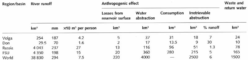
Table 5.4 Anthropogenic effects on river runoff
Note: all characteristics are annual means. Source: Koronkevich and Zaitseva (1996).
Water abstractions are particularly high in the south, where agriculture depends on
irrigation. In the Volga and the Don basins, which are among the most densely populated
and economically developed regions, 7 per cent and 30 per cent of water are abstracted for
human needs. In the 1970s, runoff in the Amudarya and Syrdarya practically ceased because
of the vast irrigation projects (Figure 5.8), this being the major cause of the Aral Sea
crisis (Mikhailov, 1997).
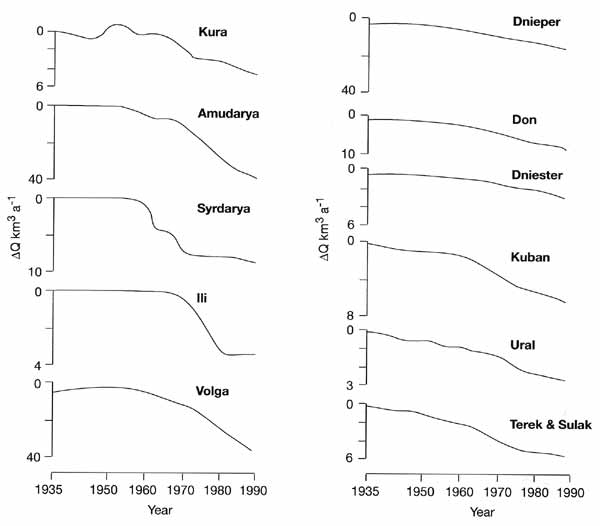
Fig. 5.8 Changes in river runoff because of economic development.
Modified from Shiklomanov (1991)
In the 1990s, less water was used because of the declining economy. However, growth in
water consumption per unit of production has been recorded (Koronkevich and Zaitseva,
1996).
The natural lack of water in the south and unsustainable use of water resources
prompted the development of water diversion projects in the 1970s and 1980s. These
projects were mainly concerned with the partial transfer of runoff from the northern
European rivers to the Volga basin, and from the Ob and the Irtysh to Central Asia.
Although the construction of support units for the European part of the project began in
the mid-1980s, both the European and Siberian water diversion projects have never taken
off. This was partly due to financial constraints and partly because their potential
environmental impacts were evaluated as extremely negative and received an extremely bad
press both in the FSU and worldwide.
Construction of dams and reservoirs has been another important feature in the
development of water resources in Northern Eurasia. In the 1920s, the Soviet Union
launched a massive programme of development of hydropower by the construction of the first
dam on the river Dnieper. Since then, many large hydraulic units have been built, mainly
in north-western Russia (Karelia and the Kola peninsula), the Moscow region, the southern
Ukraine, the Caucasus, the Volga region, the Urals, Central Asia, and Southern Siberia.
Major rivers such as the Volga, Kama, Dnieper, and Angara have been transformed into a
chain of reservoirs. About 45 per cent of the total water volume (about 1200 km3)
in Eastern Siberia and the Far East, which accommodate some of the world's largest rivers,
belongs to the artificial reservoirs. The largest Bratsk reservoir, built on the Siberian
river Angara, has a volume of 169.8 km3. The Kuibyshev reservoir located on the
Volga is the largest in the European territory with a capacity of 56 km3.
The impacts of reservoirs on river regimes are well known. The development of
hydroelectricity and the construction of reservoirs have substantially modified the
regimes of many rivers towards an equalization of seasonal flows. The total active storage
capacity of reservoirs of about 600 km3 (Avakyan et al., 1987) provides the
potential of reducing runoff during spring floods by more than 20 per cent and increase
runoff during the low water levels by a factor of 1.6. Although the actual change is
smaller, it is still considerable. The regime of the Volga has been modified most strongly
(Table 5.5, Figure 5.9) and similar changes have occurred on the much smaller river Don
after the construction of the Tsimlyansky reservoir (Table 5.5).
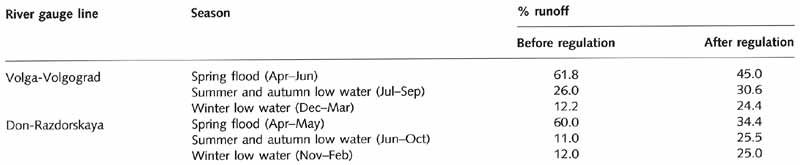
Table 5.5 Redistribution of runoff by reservoirs
Source: Grin (1971), Avakyan and Sharapov (1977).
Another important feature of the modified hydrographs is the short-term fluctuations
caused by diurnal and weekly regulations of the flow linked to demand for electricity
(Figure 5.9).
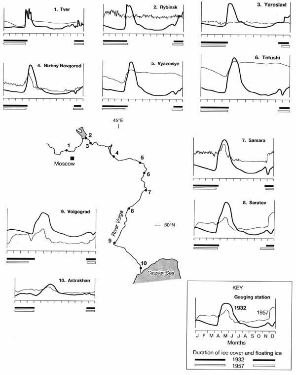
Fig. 5.9 Water level curves at the main Volga gauge lines before the
alteration of water regime in 1932 and after the alteration in 1957.
Modified from Avakyan and Sharapov (1977)
Reservoirs alter the thermal regimes of rivers. The ice regime of regulated rivers has
also changed towards a later freezing and a later release from the ice cover. Reservoirs
filter out sediment. Downstream of the reservoirs sediment discharge has declined by
almost 30 per cent in the Volga and by a factor of 1.8 in the Don (Avakyan and Sharapov,
1977). In the Caucasus and Central Asia, where suspended load is very high, rapid silting
is a serious problem for reservoir maintenance. Aquatic ecosystems are affected in many
ways. In arid regions, the reduction in spring floods results in drying of floodplains.
This effect is particularly notable in the lower courses and deltas of the Amudarya and
Syrdarya, and in the steppe and forest-steppe sectors of the Irtysh. Dam construction has
a significant impact on fish stocks through the change of habitats and disruption of
migration routes. Thus, dam construction on the Volga has resulted in the disappearance of
the natural spawning sites of migratory fish upstream of Volgograd and has significantly
reduced the stock of sturgeon.
In Northern Eurasia, large dams are built on the rivers draining plains and because of
it their reservoirs occupy vast areas. Reservoir construction in such cases leads to the
loss of productive land and necessitates resettlement, the latter often being associated
not only with economic cost but also with human stress, leading to many social problems.
Areas, submerged after the construction of reservoirs, vary. However, the largest loss of
land has occurred in Siberia where vast lands have been flooded without forest clearance.
Decomposing wood later becomes a source of water contamination.
Although river regimes have been substantially altered by these developments, it is
water quality that has been affected most strongly. In the early 1990s, about 165 km3
of abstracted water (both treated and untreated) was returned to rivers and reservoirs
annually. The average ratio of discharge to returned water was as low as 25. In the Volga
and the Don, its was 10 and 2, respectively, which is obviously insufficient to maintain
satisfactory water quality (Chernyaev, 1991; Koronkevich and Zaitseva, 1996). An enormous
volume of pollutants is brought into the rivers by runoff from urban areas and arable
lands. As a result, in almost all rivers draining densely populated regions water quality
standards are violated (Koronkevich et id., 1995). The economic decline of the 1990s,
which in many cases has reduced pressure on the environment, has not brought about a much
needed improvement in water quality because a decrease in discharge of waste water was
accompanied by a deterioration in the standards of water treatment (Danilov-Danilyan,
1995).
<<< The Thermal and Ice Regime |
Physical Geography Index | Lakes
>>>
|


