Please put an active hyperlink to our site (www.rusnature.info) when you copy the materials from this page
Biomes and Regions of Northern Eurasia
Steppe and Forest-steppe
<<< Biological Diversity | Biomes & Regions Index | The Modern
Structure of Land Use >>>
Anthropogenic Transformation of Steppe and Forest-steppe
Steppe is the main agricultural region of Northern Eurasia and 57 per cent of the area
occupied by chernozems is arable land (Table 11.2).
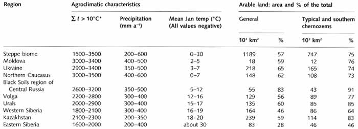
Table 11.2 Environmental characteristics and land use in the steppe
biome
The agricultural development of steppes has a very long history and three major phases
in the transformation of steppe soils are distinguished: development, degradation, and
cultivation (Kovda, 1974). In the early stages of agricultural use of steppe and
forest-steppe soils (the first few years after ploughing), yields are usually high.
However, at this stage cycling of minerals is transformed, and a decline in the contents
of organic matter, nitrogen, and phosphorus and degradation of the physical and moisture
properties of the soil occur. If no organic fertilizers are applied, soils degrade. The
fertility of chernozems starts to decline, followed by a changing morphology (compaction)
of the soil, a sharp decline in yields, and their subsequent stabilization at a much lower
level. Cultivation of chernozems refers to its rational and sustainable use which is only
possible if fertilizers are used in order to compensate for the loss of natural fertility.
The maintenance of the optimal balance of organic matter and other nutrients makes its
possible to obtain high yields while preserving or even improving chernozem fertility.
Farming over a long period has considerably altered the properties of chernozems and
particularly their organic matter content. In the 1980s, data were published illustrating
the loss of organic matter, which occurred during the last hundred years since Vasily
Dokuchaev began studying chernozems (Rozanov, 1983). Thus in 1881, the humus content in
the uppermost 30 cm layer varied between 10 per cent and 13 per cent in the typical
chernozems of the Voronezh region in Central Russia while its humus reserve was estimated
as 30-39 thousand t km-2. By 1981, these values had decreased to 7-10 per cent
and 21-30 thousand t km-2. The total loss of organic matter over the last
hundred years was, therefore, 9000 t km-2 in all or 90 t km-2 each
year. In the Stavropol region, organic matter declined at the rate of 70-80 t km-2
a-1, in the Orenburg region at the rate of 90 t km-2 a-1,
and in the leached chernozems of the Ulyanovsk region at the rate of 270 t km-2
a-1. On average, the loss of organic matter over the last hundred years is
estimated as 20-35 per cent in the Black Soils region of Central Russia, Northern
Caucasus, and the Orenburg region, and as 56-69 per cent in the forest-steppe of the Volga
region (Chesnyak et. al., 1983).
Soils of the European steppe and forest-steppe are highly susceptible to the formation
of gullies and erosion which in turn contribute towards the intensive loss of organic
matter from soils. The physical geography of the southern East European plain (e.g.,
parent rocks are mainly loess and chalk; the high intensity of summer rainfall; and
freeze-thaw effects) predetermines the naturally high erosion rates. However, the major
cause of landscape degradation is anthropogenic and the most important is the removal of
natural vegetation and the cultivation of land. The elimination of shrubs and tall
grasses, which delayed snow melt in spring, minimized surface runoff and maintained high
ground water levels, resulted in less moisture accumulation in soils, thereby increasing
their credibility. In addition, traditional agricultural techniques (emphasis on grain
cultures in the three-field system, shallow ploughing) favoured the development of
erosion. The origin and history of soil erosion in the southern East European plain have
been studied by many scientists and Stebelsky (1974, 1983) provides a good summary.
Although the chernozems of the East European plain have been cultivated since the
Neolithic, there is little evidence for early land degradation. The 14th-century
chronicles only occasionally mention dust storms, and there are no reports of these in the
forest-steppe zone. However, land inventories compiled in the 16th century mention the
occurrence of gullies, both active and stabilized and wooded, in what is now the Tula
region, thus testifying to earlier periods of soil erosion (Stebelsky, 1983). During the
16th and 17th centuries, the forest-steppe and steppe were rapidly settled and extensive
lands were cultivated, but it was in the 19th century when most of the expansion took
place. During that century, the rural population more than doubled from 6 to 12.8 million
people in what is now the Black Soils region (Stebelsky, 1974). With no growth in
industrial employment and improvements to agricultural techniques, the agrarian
development placed increasing pressure on land resources. By the end of the 19th century,
about two-thirds of the land were cultivated in the Black Soils region and the pressing
need for land caused river terraces and slopes to be ploughed. Much of the rich farmland
was lost to the formation of gullies and landscapes of forest-steppe and steppe zones were
permanently altered (Stebelsky, 1983).
As often happens, environmental change was accompanied by growing poverty, conflict,
and eventually social crisis. In 1890, the Eighth Congress of Russian Naturalists and
Physicians approached the Ministry of State Property with a request to fund research on
gullying and soil erosion in forest-steppes and steppes. This study, completed by Masalsky
(1897), revealed widespread gullying in Bessarabia (now Moldova), Podolya, the Dnieper and
the Donetsk uplands, and particularly in the Central Russian (Srednerusskaya) and the
Volga uplands. The percentage of land occupied by gullies ranged between 0.5 per cent to
25 per cent with 3-5 per cent of the area being most commonly reported (The highest
figures were later proved to have been overstated since not only active gullies but also
ravines were included). Landowners and peasants were encouraged to take action against
soil erosion. However, most did not see a connection between land use and gullies and
considered soil erosion unavoidable and conservation measures too expensive (Stebelsky,
1983).
The work by Masalsky provided a considerable amount of descriptive material; the first
detailed maps of the level of soil erosion and gully density appeared a few decades later.
A large expedition through the European part of the FSU was conducted between 1939 and
1941 and provided data for the first general comprehensive map of soil erosion in the
European FSU. The Black Soils region of southern European Russia experienced the most
extensive soil erosion. By the middle of the 20th century, only 10 per cent of land was
not affected by gully erosion here, a medium network of gullies (0.2-0.4 km of gully per
km2) covered about 30 per cent of land, and a dense network (0.5-1.2 km of
gully per km2) covered another 35 per cent (Sobolev, 1948; Guzhevaya, 1948).
At present, landscapes of the steppe and forest-steppe biome are at different stages of
anthropogenic transformation. The following categories can be distinguished: pristine
landscapes; lands used for grazing with intermittent arable agriculture (this land use
corresponds to nomadic livestock breeding); arable lands with extensive agriculture; and
arable lands with modern agriculture (Krupennikov, 1983). There are very few regions where
virgin steppes occur, and possibly only steppes protected in nature reserves fall into
this category. Nomadic land use was typical of the European steppe until the beginning of
the 19th century, in northern Kazakhstan it existed until the 1950s and at present is
practised in the Altay steppes. The most typical example of extensive agricultural land
use was the infamous Virgin Land project of the 1950s, which aimed at the expansion of
arable agriculture into the steppes of northern Kazakhstan and Southern Siberia. Intensive
agriculture is practised in the forest-steppe and steppe of the Ukraine, Northern
Caucasus, the Black Soils region of Central Russia and the Volga region. The scale of
transformation of the steppe and forest-steppe biomes is illustrated in Tables 11.2 and
11.3.
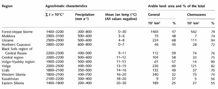
Table 11.3 Environmental characteristics and land use in the
forest-steppe zone
Thus, in the Ukraine, the Black Soils region of Central Russia, the Volga region, and
Kazakhstan between 74 per cent and 91 per cent of flat, well-drained plains with chernozem
soils is occupied by arable fields. The remaining 10-20 per cent is usually not a natural
steppe or forest-steppe but, on the contrary, an anthropogenic landscape.
<<< Biological Diversity | Biomes & Regions Index | The Modern
Structure of Land Use >>>
Contents of the Steppe and Forest-steppe
section:
Other sections of Biomes & Regions:
|
|


