Please put an active hyperlink to our site (www.rusnature.info) when you copy the materials from this page
Biomes and Regions of Northern Eurasia
The Mountains of Northern Russia
<<< The Ural Mountains | Biomes & Regions Index | The Mountains of
North-eastern Asia >>>
The Putorana Plateau
Located in the north-west of the Central Siberian tableland, the Putorana plateau is
its most elevated part. Steep slopes separate the plateau from the rest of the region in
the west, north and east. In the south, it slopes gradually towards the Syverma plateau;
the boundary between the two passes approximately along 66°N. The name of Putorana, which
in Evenk means 'lakes with steep shores', summarizes the major features of its landscape.
The plateau was first mapped and described between 1725 and 1730 by Chichagov (Magidovich
and Magidovich, 1984). The first detailed map was not completed until the 1940s when
aerial photography was available and the elevation of it highest summit (Mount Kamen, 1664
m) was established at the same time.
Morphology and Environmental History
The Putorana plateau is a morphostructural element of the Siberian platform. In the
Paleozoic, the region was a part of the subsiding Tungus basin. The Paleozoic platform
cover consists of sandstone, aleurite, argillite, and coal strata exposed along the
western and eastern margins of the plateau (Figure 13.5).
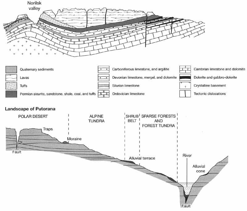
Fig. 13.5 Geology and landscapes of the Putorana plateau. Modified from
Parmuzin (1975)
In the late Permian and Triassic, the rigid block of the Central Siberian tableland was
broken by the Variscan orogeny and volcanic rocks intruded the Paleozoic strata and
extruded on the surface. Potassium-argon dating has shown that volcanism began in the
Putorana around 240 Ma BP and reached its peak around 235-220 Ma BP (Zolotukhin and
Almukhamedov, 1988). Central Siberia is one of the few regions in the world that
experienced extensive basaltic magmatism. Originally, volcanic rocks are believed to have
covered an area of about 1.5 x 10⁶ km2 with an average thickness of about 1 km.
At present, the extrusive basalts occupy about 337 thousand km2 with a magma
volume of about 337 km3 (Ravniny i gory Sibiri, 1975) which places the Siberian
flood basalt province among the world's largest such as the Columbia river province in the
north-western United States and the Deccan Traps in central and north-western India
(Basaltic Study Project, 1981). Over 90 per cent of the Siberian basalts occurs in the
Putorana and the high elevation of the plateau is partly due to the great thickness of the
lava which in its central part reach 2000 m (Ravniny i gory Sibiri, 1975). Products of
fissure eruptions occur in a variety of conditions: as blanket deposits 20-150 m thick
interlaid with tuffs and sedimentary rocks (termed traps), thick dykes and columnar
structures. Associated with the intrusions are the deposits of copper and nickel. The
largest deposits occur at the western margin of the plateau in the Norilsk region and
because of their economic importance regional geology is well researched and a wealth of
literature is available. A review paper by Zolotukhin and Almukhamedov (1988) on the
Siberian basaltic province is recommended to English-speaking readers as well as papers by
Nesterenko et al. (1991) and Sharma et al. (1991) which deal with the Putorana traps.
Between the upper Cretaceous and the Neogene, the Putorana had a stable regime and
under the conditions of subaerial exposure underwent prolonged denudation. At the end of
the Neogene-beginning of the Pleistocene, the area experienced an upwarp reaching 800-1500
m. A system of faults, centred on Lake Ayan developed, breaking the swell into individual
mountainous massifs separated by deep, narrow valleys which now contain rivers and lakes.
The uplift of the area continues.
There is a difference in opinion on the number of glaciations in the Putorana region in
the early Pleistocene. According to Isaeva et al. (1986) the area was glaciated once
whereas Alekseev et al. (1984) distinguish two separate glaciations. A similar controversy
exists concerning the middle Pleistocene glaciations: Isaeva et al. (1986) suggest that
the Putorana was glaciated twice, while Arkhipov et al. (1982) recognizes three
glaciations. In contrast to the North Siberian lowland, where the Quaternary stratigraphy
is relatively well preserved, tectonic movements and a lack of organic deposits limit the
availability of the reliable Pleistocene sequences in the Putorana and only the late
Pleistocene environments can be reliably analysed. Four stages are distinguished within
the late Pleistocene: Kazantsevsky interglacial, Zyryanka (70-50 Ka BP) and Sartan (22-15
Ka BP) glacials separated by the climatically complex Karginsky interval (see Table 2.1 and Figure 2.3). Deposits of
Putorana origin found in the valleys of the Khatanga and Kheta suggest that the plateau
was one of the centres of the Zyryanka glaciation in northern Central Siberia (Isaeva et
al, 1993). In the early maximum stage of the Zyryanka, the Putorana ice sheet merged with
those of the Byrranga and Anabar centres and formed a single cover which occupied the
northwestern sector of the Central Siberian tableland (Isaeva, 1984). The Karginsky
interval included three warmings and two coolings and it is possible that during the early
warming at 40-45 Ka BP the climate was warmer than today and glaciers degraded completely
(Arkhipov et al., 1982). The subsequent cooling led to the development of the Sartan
glaciation whose extent in Central Siberia was smaller than that of the Zyryanka, despite
the lower temperatures. Only in the north-west of the North Siberian lowland did the
Putorana glaciers merge with those of the northern centre located on the Kara shelf
(Isaeva, 1984). The position of the end moraines indicates that during the maximum phase
at 18-20 Ka BP, the Putorana ice crossed to the western bank of the Yenisey and made the
river shift westwards (the evolution of river valleys in periglacial areas is discussed
above). It is in the western sector of the plateau that the glacier was most active and
reached its maximum extent and a thickness of 1-1.5 km. In the north, valley glaciers
merged in the piedmonts. At the southern and eastern margins of the Putorana, ice advanced
along valleys, and the frontal parts of the ice sheet were stagnant and did not leave a
continuous terminal moraine (Isaeva, 1984; Isaeva et al., 1993). The retreat of piedmont
glaciers ended around 15 Ka BP but glaciers continued to exist in the mountains. Thus,
between 500 m and 1300 m, end valley moraines recorded eight pauses during the Holocene
ice retreat (Maksimov, 1969).
The modern relief of the Putorana plateau is a product of epeirogenic movements,
faulting, fissure magmatism, erosion, and glacial activity. Typical of the Putorana is a
combination of flat watersheds, table mountains, and deep valleys (Figure 13.5). Flat
summits (1400-1500 m) and terraces positioned at 700-800 and 1000-1200 m are remnants of
the ancient peneplain, while major valleys correspond to faults which are represented by
various forms from mature grabens to recent fissures. Most strongly dissected is the
western part of the plateau where relative elevations range between 500 m and 1000 m. The
hydrographic pattern generally corresponds to the tectonic structures. River valleys are
mostly narrow and deep with numerous straight sections. The alternation of basalts, tuffs,
and sedimentary rocks and their different resistance to weathering predetermine a
widespread occurrence of cornices and breaks in the longitudinal river profiles.
Associated with those are numerous waterfalls, a distinct feature of the Putorana
landscapes. Similarly, slopes have characteristic profiles with 15-20 levels. Valleys
contain numerous lakes which are usually very deep (e.g., Lake Lama, 250 m), long (e.g.,
Lake Dyupkun, 133 km) and narrow. There are just under 10 000 lakes in the Putorana
(Parmuzin, 1975).
Climate and Cryogenic Phenomena
There are three climatic sectors in the Russian Arctic and subarctic: Atlantic,
Siberian and Pacific (Myachkova, 1983). The boundary between the Atlantic and the Siberian
sector is positioned at approximately 94°E. The Putorana is, therefore, located at a
junction of the two sectors and its western and eastern regions have different climates.
The western part of the plateau receives twice as much precipitation as the eastern one,
with the annual totals increasing from 300-400 mm in the foothills to 1200-1600 at the top
(Myagkov and Kanaev, 1992). The average depth of snow cover increases from 60-80 cm to
100-150 cm and the duration of snow cover increases from 200 -240 to 280-300 days. The
modern glaciation is confined to the north-western region (the Pyasina basin) where 19 out
of 22 glaciers are located. The equilibrium line rises from 800 m in the north-west to
1300 m in the Khatanga basin located further east. All glaciers are small, with a combined
area of 2.5 km2, and develop on the north-eastern slopes where melting is
delayed in sites protected from wind. While the medium elevation of the Putorana restricts
the formation of extensive glaciation, the prolonged cold season (monthly mean
temperatures are positive only between June and August) and sufficient snowfall favour the
development of snowbanks. These are often 10-15 m deep and on the eastern and
north-eastern slopes they develop into perennial snow packs (Popov and Parmuzin, 1975;
Osokin, 1989). Snow patches and snow packs frequently dam streams and small rivers,
leading to the formation of summer floods and mudflows. Strong slushflows occur on average
once in four years during the thawing period between May and June under the condition of
rapid temperature increase; less frequent are mudflows in July-August which develop as a
result of intensive rainfall (Perov, 1989).
The Putorana rivers have the East Siberian regime distinguished by a high water
discharge in late spring following thawing and extremely low levels in winter when many
rivers freeze through to the bottom (Figure 5.6).
Similar to many other Siberian regions, icings are a typical feature of the Putorana
hydrology. Icings develop on the frozen surfaces of streams and rivers and when seepage
water freezes. Satellite imaging has shown that about 2000 icings with a combined area of
about 2400 km2 and an estimated volume of 3 km3 form every year
mainly between 500 m and 600 m (Gienko, 1990). Indeed, 'a land of lakes and icings' seems
to be an appropriate name for the Putorana. The eastern part of the plateau, where winter
climates are more severe and arid, is particularly prone to their formation. Icings are an
important control over river regime: while in winter they can terminate river discharge
completely, in summer an additional input of water is provided. Persisting over most of
the warm season, icings affect biota and in river valleys and around springs vegetation is
often replaced by sand and gravel deposits.
The Putorana plateau is located in the cryolitho-zone. In the foothills, permafrost is
discontinuous and occupies 60-70 per cent of the area. The depth of permafrost varies
between 10 m and 80 m and its temperature is about -3°C. With altitude, continuity and
thickness of permafrost increase while its temperature declines (Yershov, 19896). At an
elevation of 700-800 m, the depth increases to 100-200 m on the slopes and 300-400 m on
watersheds; at 1000-1100 m it varies between 500 m and 800 m and can reach 1100 m at an
elevation of 1600 m with the permafrost temperature being as low as -11°C. Therefore,
frozen rocks and ground occupy almost the whole of the Putorana and taliks (areas of
unfrozen ground or thawed permafrost; see above) occur only under rivers and lakes. The
depth of the active layer varies between 1-2 m in the upper parts of the slopes and 2-3 m
in the lower sections and in the valleys.
The severe climate and permafrost predetermine a widespread development of cryogenic
processes and associated landforms (e.g., solifluction, the formation of frost mounds and
patterned ground) in the Putorana (Rogozhin, 1966; Fotiev et al., 1974). The formation of
block fields and taluses is extremely intensive and occurs on a particularly large scale,
partly because of the low temperatures but also because trap has an exceptional tendency
towards disintegration by frost weathering. The formation of cryogenic eluvium began in
the glacier-free locations during the Sartan and many relict cryogenic features are found
alongside the modern ones (Isaeva et al, 1993). The continuing uplift of the plateau
intensifies the formation of block fields and block streams (termed kurums) and their
downslope movement.
Soils and Biota
Until the 1970s, the vegetation of this region was only known through the early works
of Shumilova (1939, 1964). However, as a result of extensive botanical surveys
subsequently conducted in the region, the Putorana has become one of the most thoroughly
studied regions in the Russian Arctic and subarctic. The findings of this research
programme are summarized in a monograph Flora of the Putorana (Malyshev, 1976a).
Most of the Putorana plateau is located in the subzone of the northern taiga
represented in this area by sparse forests. Altitudinal gradients exist in the
distribution of vegetation but in comparison to the mountains in the south or in the west,
the vertical vegetation sequence is simple. Three major altitudinal zones are
distinguished: sparse forests and forest-tundra (extending to 300-400 m in the north and
700-800 m in the south); alpine tundra (reaching 1200-1400 m) and polar desert. A narrow
belt of shrubs, composed mainly of Alnus fruticosa, Salix spp., and Betula ďŕďŕ,
separates the sparse forest and the alpine tundra zones and is sometimes recognized as a
separate belt (Kuvaev, 1980). In the western part of the plateau, the forest zone is
better developed. Forests are composed mainly of Larix sibirica and L. gmelinii (in older
texts referred to as L. dahurica) and have a developed undergrowth of Alnus fruticosa and
Betula nana. The western part of the Putorana is positioned at a boundary between the dark
taiga and the larch taiga, and forests dominated by two species, Picea obovata and Larix
sibirica with the participation of Betula tortuosa occur. Eastwards, the composition of
forests becomes extremely poor. Larix gmelinii is one of very few woody plants that can
tolerate the extremely low temperatures, aridity and thin active layer and sparse forests
in the eastern Putorana are composed solely of this species. The alpine tundra vegetation
is represented by dwarf shrub, moss, and lichen communities while crust lichens are the
main plants in the zone of polar desert. The alpine belt widens towards the north where
the forest belt occupies limited areas or is even absent. With the exception of the
south-western part of the Putorana, soils are poorly developed (Sokolov and Tonkonogov,
1975). The soil cover is usually thin, rocky with a thin layer of turf or peat near the
surface. The cryogenic mixing of the ground prevents the development of a differentiated
profile.
The flora of the Putorana comprises 576 species and is represented mainly by the
circumboreal and amphi-Beringian (i.e., common on both sides of the Bering Strait) species
for which the Putorana is the westernmost limit of distribution (Malyshev, 19766). While
there is a close affinity between the Putorana and Beringia, notable gaps exist between
the Putorana and the main distribution centres in Western and Central Siberia (Yurtsev et
al., 1971; Nimis et al., 1995). Vodopyanova (1976) suggests that the existance of such
gaps and the occurrence of the Pliocene relicts, such as Rhododendron aureum, point at a
possible refugial role of the Putorana during the Pleistocene glaciations. This view
contradicts the concept of cover glaciation of the Putorana and supports the existence of
ice-free areas and relatively warm habitats during glacial times. Alternatively, the more
heat-demanding plants could have reached the plateau in the warmer periods surviving later
only in the protected sites on the south-facing Putorana slopes (Nimis et al,, 1995).
Despite its remote location and the hostile environment, the Putorana accommodates
considerable economic activity. Already in the 1920s-1930s, the vast deposits of copper
and nickel ores were discovered in its western foothills and production at the Norilsk
Metallurgical Combine began in 1942. At present, the town of Norilsk has a population of
over 160000 and is one of the world's largest Arctic settlements. The Norilsk Combine is
the leading producer of non-ferrous metals and, similarly to the smelters of the Kola
peninsula and Sudbury (Ontario, Canada), it is a source of environmental degradation of a
catastrophic scale. These issues are discussed below.
<<< The Ural Mountains | Biomes & Regions Index | The Mountains of
North-eastern Asia >>>
Contents of the Mountains of Northern Russia
section:
Other sections of Biomes & Regions:
|
|


