Please put an active hyperlink to our site (www.rusnature.info) when you copy the materials from this page
Biomes and Regions of Northern Eurasia
The Mountains of Southern Siberia
<<< The Sayan Mountains | Biomes & Regions Index | The Stanovoy and
the Dzhugdzhur Ridges >>>
Mountains of the Baikal Region and Transbaikalia
The mountains of Baikalia and Transbaikalia occupy a vast area between 51-57°N and
100-125°E, extending for nearly 2000 km from west to east. They are limited by the
Lena-Angarsk plateau in the north and by the Mongolian border in the south. They are
separated from the Eastern Sayan in the west by the Tunkin graben and from the Amur region
in the east by the Olekma river. The mountains extend in meridional and submeridional
ridges (Figure 14.8) with altitudes ranging from approximately 3000 m (the Kodar Ridge) to
200-400 m in the lower courses of the Shilka and Argun.
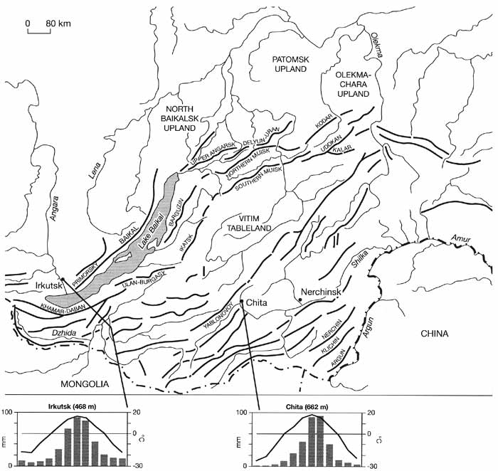
Fig. 14.8 Orographic scheme of the Baikalian and Transbaikalian
mountains and annual temperature and precipitation distribution in several regions
The whole area is traditionally subdivided into the Baikalia and Transbaikalia.
Baikalia includes the Primorsky and Baikal Ridges which comprise the so-called western
Baikalia; Khamar-Daban mountains (southern Baikalia); and Ulan-Burgasy, Ikatsk, and
Barguzin Ridges which form eastern Baikalia. Transbaikalia is subdivided into western (the
Vitim tableland); central which extends from the Dahurian Ridge in the south-west to the
Olekma river in the north-east; and eastern including the low mountains in the basins of
the Shilka and Argun. The southern part of Transbaikalia is also known as Dahuria. The
Yablonovoy Ridge in central Transbaikalia forms a divide between the basins of the Arctic
and Pacific Oceans and is an important biogeographical boundary. More detailed regional
models distinguish two other entities: the Stanovoy upland, which extends between the
northern tip of the Baikal and the Olekma and includes the Upper Angarsk, Delyun-Uran,
Northern Muisk, Southern Mulsk, Kodar, Udokan, and Kalar Ridges; and the northern
Baikalian uplands which comprise three elevated tablelands separated by valleys that
coincide with tectonic faults: North Baikalsk, Patomsk, and Olekma-Chara.
Environmental Change
The climate of the Baikalian and Transbaikalian mountains is highly continental with
extremely large seasonal temperature fluctuations and moderate or small amounts of
precipitation (Figure 14.8). Most of the area is underlain by permafrost. Broadly similar
climatic conditions became established in the region at the end of the Pliocene, when
strong climatic cooling occurred and heat-demanding savannah vegetation was replaced by
boreal vegetation. The main characteristics of the contemporary landscapes have been
determined by the events of the last 2 million years or so (Belova, 1983; Isaeva et al.,
1993). The paleoclimatic history of the region is best reconstructed from the sedimentary
record of Lake Baikal which is uninterrupted by the Pleistocene ice sheets and spans the
last 20 million years. Many Russian and international scientific teams have been
researching the Baikal record and their results are discussed below. This section briefly
examines environmental change in the mountainous regions in the late Pleistocene. The
evidence for past changes has been obtained mainly in the mountains of Baikalia, western
Transbaikalia, and in the northern Baikalian and Stanovoy uplands. This section is based
on the summaries by Belova (1983) and Isaeva et al. (1993). The late Peistocene (120-10 Ka
BP) includes four intervals that correlate with the Kazantsevsky and Karginsky
interglacials and Zyranka and Sartan glacials (Table
2.1). Deposits of the Kazantevsky interglacial (120-95 Ka BP) are represented mainly
by alluvial and lacustrine sediments which fill the intermontane depressions and form
river terraces. In the North Baikalsk upland, the pollen record of the optimum of the
Kazantsevsky interstadial shows Pinus sibirica and Pinus sylvestris, some Abies sibirica
and Picea obovata, and in most favourable habitats Tilia and Corylus avellana
(Rindzyunskaya and Pakhomov, 1977). Broad-leaved species occurred in many valleys from the
Tunkin in the south-west to the Chara in the north-east; Quercus mongolica and Corylus
avellana featured as an admixture in pine forests and in the forest-steppe zone in western
Transbaikalia. On the other hand, pollen records in the Baikalian mountains have revealed
a high (70-90 per cent) proportion of cold-tolerant tree species such as Pinus sylvestris,
Picea obovata and Betula. The general sequence of vegetation development during the
Kasantsevsky interglacial has been summarized by Isaeva et al. (1993) who propose the
following pattern: (I) at the beginning of the interglacial sparse Pinus sylvestris and
Larix-Pinus sylvestris forests dominated, indicating that climatic conditions were similar
to those of today; (II) during the optimum, temperatures appear to have been higher than
those of the present with the frost-free period reaching 130-145 days; precipitation was
more abundant and dark coniferous forests with the participation of broad-leaved species
spread north of the Baikal; (III) towards the end of the interstadial, following the
deterioration of climatic conditions, a reduction in thermophilous genera occurred, and
there was a return to boreal forests dominated by Pinus sylvestris, Betula, and Alnus.
Glacial and fluvioglacial deposits of the Zyranka stadial (95-50 Ka BP) and moraines
dated to that time are widespread in the northern Baikalian uplands and in the Baikalian
mountains. The extent of deposits and the variety of glacial landforms significantly
exceed those of the Sartan time (with the exception of the Barguzin and Ungdar Ridges
where the Zyryanka and Sartan glaciers occupied approximately the same areas) implying
that the ice reached its maximum distribution in the late Pleistocene. The glaciation was
of a mountain valley type and the position of terminal moraines indicates that glaciers
descended to an altitude 1000 m in the mountains of Baikalia and 400 m in the Vitim
upland. There are geomorphological indications that the Zyryanka glaciation was
interrupted by phases of less severe climate and less intense glacial activity producing
terraces of different levels, containing Zyryanka alluvium, and allowing a number of
terminal moraines to develop. However, no deposits that could be confidently attributed to
an interstadial have been obtained yet and in their absence it is obviously impossible to
reconstruct a precise sequence of events. In periglacial regions of the North Baikalsk
upland, the pollen record is dominated by Lycopodium pungens and L. alpinum,
characteristic of swamped habitats, and there are also Betula ďŕďŕ and Alnus. This
suggests that at the beginning of the glacial, to which this record is dated, the
vegetation was dominated by sparse forests alternating with swampy tundra. In the Barguzin
Ridge, the pollen record dated to the glacial maximum, reveals the existence of
tundra-steppe vegetation with the participation of dwarf birch and Artemisia. The climate
of the Zyryanka was more humid and less severe than that of the Sartan. The annual
precipitation totals ranged between 250-300 mm, mean January temperature was about -35°C,
mean July temperature was about 10-15°C and the frost-free season lasted about 50 days
(Figure 14.9).
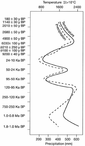
Fig. 14.9 Climatic change in the mountains of southern Eastern Siberia.
After Belova (1983)
Climate fluctuated during the Karginsky interstadial (50-24 Ka BP) which separates the
Zyryanka glaciation and the Sartan. A most notable amelioration of climate occurred
between 50 and 33 Ka BP when Pinus sylvestris-Larix and Pinus sylvestris-Betula forests,
with the participation of broad-leaved woody species and steppe species in the herbaceous
cover, developed in the valleys of western Transbaikalia. In the North Baikalsk upland,
woody species account for as much as 60-90 per cent of pollen and that of Pinus sibirica
is most abundant. The climate became cooler between 33 and 30 Ka BP when broad-leaved
species declined in the north-western
Transbaikalia and the participation of Larix gmelinii (in older texts this species is
referred to as L. dahurica) increased. During the following warm stage (30-22 Ka BP), the
forest-steppe associations became widespread and steppe vegetation developed south of the
river Selenga. It was at that time that Larix gmelinii, the most common modern woody
species in Transbaikalia, became a significant component of the forest-steppe. In all, the
Karginsky flora contained about 180 species including the Arctic species which survived
from the Zyranka glacial and heat-demanding broad-leaved trees which are not found in
Baikalia and Transbaikalia at present. The composition of the Karginsky vegetation
indicates that climatic continentality and aridity have increased in comparison with the
Kazantsevsky interglacial. The frost-free period continued for 120-130 days and annual
precipitation totals ranged between 300 mm in the south-east and 500 mm in the north.
The Sartan (24-10 Ka BP) was marked by the expansion of glaciers, particularly in the
following mounatinous regions: the North Baikalsk upland, the southern Patomsk upland,
mountains of Baikalia (especially the Barguzin and Ungdar Ridges), the Stanovoy upland
(especially the Upper Angarsk Ridge), at the junction of the Northern Muisk and
Delyun-Uran Ridges and in the Southern Muisk Ridge. Different types of glaciers developed
in the northern Baikalian and Stanovoy uplands and in the Baikalian mountains. In the
Barguzin and Ungdar Ridges, open to the westerly flow and the local winds from Lake
Baikal, mountain valley glaciers dominated and cirque glaciers also developed. The cirque
floors are positioned at about 1400 m while valley glaciers descended lower to an altitude
of 600-700 m reaching a length of 100 km. They often filled small intermontane
depressions, forming ice reservoirs. Along the western slopes of the Barguzin, and
especially the Undgar, they reached into the foothills, forming a piedmont glacier. The
western foothills of the Barguzin are perhaps the only region where fluvioglacial deposits
are abundant and form a hilly outwash plain. In the uplands, where climate was drier,
cirque glaciers dominated and rugged alpine topography is now typical in the areas of
their most widespread development. The altitude of the cirque floor was 1100-1200 m, being
positioned higher at 1500-1600 m in the Patomsk upland. Glaciers were mostly restricted to
the cirques and only rarely did they advance along narrow troughs forming the so-called
hanging glaciers. These were relatively small glaciers with a length of about 10 km (2-4
km in the Patomsk upland). They reached the upper parts of the valleys only infrequently.
Only in the northernmost Patomsk upland did the ice reach an altitude of about 1000 m,
being otherwise restricted to 1400 m. The vegetation of the Sartan was of an open nature.
In the periglacial areas of the Baikalian mountains, northern Baikalian and Stanovoy
uplands tundra or forest-tundra with the participation of xerophilous species dominated
(Fedorova et al, 1968; Rindzyunskaya and Pakhomov, 1977; Isaeva et al., 1993). Pollen of
herbaceous plants (of which Artemisia was most common) and dwarf shrubs account for about
70 per cent of the spectrum, while dwarf birch (a typical tundra plant) accounts for the
highest proportion of the woody plant pollen. Tundra and forest-tundra extended
approximately between the latitudinal stretch of the Angara in the north-west to the upper
course of the Kirenga (about 53°N; 115°E). Further south, Larix gmelinii forests of the
northern taiga type developed at low elevations, while in the intermontane depressions of
western Transbaikalia forest-steppe associations with Larix gmelinii occurred. The climate
of the Sartan was more severe than that of the Zyryanka in accord with the development of
the Siberian anticyclone. Although there were phases of milder climate, in general the
mean annual temperature was about -15°C, the frost-free period lasted for 30-40 days and
annual precipitation was limited to 190-200 mm. Glaciers occupied smaller areas but, in
the absence of ice, the formation of permafrost was both intensive and extensive. Frost
weathering and the formation of kurums proceeded intensively in southern and eastern
Baikalia where cryogenic eluvium typical of the low watersheds is thought to be of Sartan
age because at present a well-developed vegetation cover limits its formation.
The amelioration of climate at the beginning of the Holocene was marked by the
replacement of tundra and forest-tundra vegetation by sparse Pinus sylvestris and Betula
forests in the Patomsk upland and mountains of Baikalia and sparse Pinus sylvestris-Pinus
sibirica forests with a well-developed herbaceous cover in the North Baikalsk upland.
During the Holocene climatic optimum, these were in turn replaced by dark taiga dominated
by Picea obovata (Kazakevich and Reverdatto, 1972). Pinus sibirica forests developed on
the watersheds of the Khamar-Daban mountains (Zubarev, 1981). Climatic fluctuations
continued throughout the Holocene. The drier conditions marked the Subboreal when dark
coniferous forests were widely replaced by the pine forests (Vipper and Golubeva, 1976)
and colder climate was typical of the mid-Subatlantic when the timber line became markedly
lower and Pinus sibirica woodlands in the middle Khamar-Daban mountains were replaced by
tundra communities (Zubarev, 1981). There are few reconstructions of the climatic
conditions during the last millennium and those available refer mainly to the Baikal
coastal regions. An exception is a dendrochrono-logical record produced by Lovelius (1979)
for the subalpine zone of the Kodar Ridge which shows that the end of the 17th century
was, perhaps, the coldest time during the last thousand years. The most recent climatic
warming began in the 19th century and this conclusion is supported by instrumental
observations which started in Nerchinck in the middle of the 19th century (Obyazov, 1996).
Modern Climate and Biota
The modern climate of Baikalia and Transbaikalia is ultracontinental with extreme
seasonal variations in temperature and a moderate or small amount of precipitation (Figure
14.8). Annual precipitation totals range between 400-500 mm in the northern uplands and
200 mm in the depressions of central and eastern Transbaikalia. The two major seasonal
atmospheric controls are the Siberian anticyclone in winter and the Inner Asiatic
depression in summer. The Siberian high forces sunny, dry, and extremely cold winters. The
lowest temperatures of about -50°C to -60°C are observed in the Chara depression. Local
topography (i.e., vast topographic depressions and uplands) intensify the development of
high atmospheric pressure. In Transbaikalia, anticyclonic weather is observed on average
on 25 days in January and only about 10 per cent of annual precipitation occurs between
November and March. The dry cold weather can occasionally be interrupted by the advec-tion
of warmer air from Central Asia (and occasionally from European Russia) to Baikalia and
more rarely from the Sea of Okhotsk or China to Transbaikalia. Snow cover is thin,
reaching 30-40 cm in the upper course of the Angara and 10-20 cm in the Nerchinsk
depression. Snow cover increases with altitude but on the whole low temperatures and the
thin snow cover favour deep freezing of soil and so maintain permafrost. In summer, a zone
of low atmospheric pressure with small pressure gradients develops. While depressions
arrive to Baikalia mainly from the west, Eastern Transbaikalia is affected by the Asian
monsoon and receives 100-150 mm of rain in summer (mainly in its second half) compared to
75-100 mm in western and central Transbaikalia (Myachkova, 1983). Summer temperatures
often reach 30°C and advection from the deserts of Mongolia and China can raise air
temperature above 35°C. Across much of the southern part of the Baikalian and
Transbaikalian mountains summer evaporation is close to precipitation which provides for
the development of the forest-steppe vegetation.
The continentality of climate is moderated by Lake Baikal although the surrounding
mountains limit the geographical extent of its influence. In the coastal zone, mean
January temperature is about 10°C higher than in the areas positioned at the same
latitude but outside the Baikal depression and temperature inversions, one of the most
typical climatic features of the region, do not develop over the lake. Although severe,
the climate of the Baikal has many maritime features (e.g., autumn is warmer than spring).
Because of the enclosed character of the valley, annual precipitation totals vary between
200 mm on the western coast and 400 on the eastern coast. Only the northern slope of the
Khamar-Daban, which intercepts moisture delivered by depressions travelling from the
north-west and regenerated over the Baikal, receives up to about 1300 mm and has a depth
of snow cover of about 1 m, while the western macro-slope of the Barguzin Ridge receives
about 900 mm (Myachkova, 1983).
Meagre winter precipitation and hot summers do not favour modern glaciation. Glaciers
with a combined area of 15 km2 develop only on the north-western macroslope of
the Kodar due to the northern position of the ridge and its high elevation (maximum
elevation 3000 m). The snow line is between 2200 and 2600 m and valley glaciers are small,
reaching 1-2 km in length.
Three main types of vegetation dominate Baikalia and Transbaikalia: taiga,
forest-steppes, and steppes. Their distribution depends on geographical position and
topography. Thus steppes form a zonal biome in Dahuria, extending from the Mongolian
border to 53°N between the Baikal and the river Argun. However, steppes and
forest-steppes also occur in the north in valleys and depressions where the climate is dry
(e.g., the Barguzin valley; 55°N) while individual steppe associations are found as far
north as Sakha-Yakutia. North of approximately 53°N, zonal vegetation is that of the
taiga. There is a notable difference in composition of the Baikalian and Transbaikalian
taiga. In Baikalia, where summer temperatures are lower and there is more precipitation,
dark taiga composed mainly of Pinus sibirica and Abies sibirica is prominent. In western
Transbaikalia, larch forests dominate while Pinus sibirica and Abies sibirica occur as an
admixture. Eastwards of the Yablonovoy Ridge under the dry conditions and the widespread
occurrence of permafrost, forests composed of Larix gmelinii and Pinus sylvestris develop
and only in the east do Picea ajanensis and some deciduous species penetrate from the Amur
region. Steppes and forest-steppes do not form a continuous belt in Baikalia but occur
locally in locked-in valleys and on the south-facing slopes. In these habitats, steppe
communities develop on the dark-chestnut and chernozem soils and comprise both steppe and
meadow species. Woody vegetation in the forest-steppes is represented by Pinus sylvestris,
Larix, and Betula spp. Forest-steppe vegetation is particularly widespread in the Dzhida
Ridge where it reaches an altitude of 1100 m and locally 1400 m.
Baikalia and Transbaikalia are mountainous regions and zonal vegetation patterns are
disrupted by vertical zonality. There are three main types of vertical sequences (Figure
14.10).
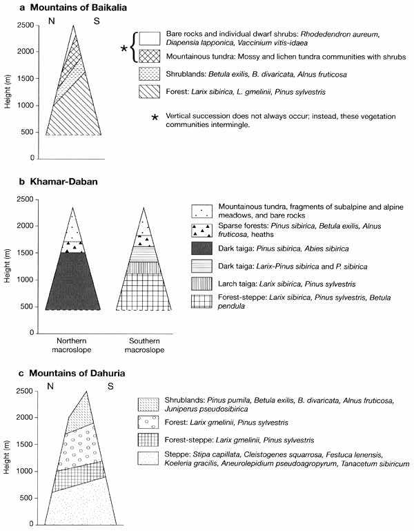
Fig. 14.10 Vertical vegetation sequences in the mountains of Baikalia
and Transbaikalia. Modified from Stanyukovich (1973); Ogureeva (1999a)
A typical vertical sequence of Baikalia, western and central Transbaikalia begins with
Larix sibirica and Pinus sylvestris forests which are progressively replaced by Larix
gmelinii north-eastwards where permafrost is more widespread. In the south, forests are
not dense and shrub and herbaceous cover are well developed. A particularly widespread
association is that with Alnaster fruticosus and Rhododendron dahuricum. In the north,
forests are often swamped and larch forms associations with Rhododendron dahuricum, and
such cold-resistant species as Betula divaricata, B. exilis, and Ledum palustre. In
contrast to the Altay and the Western Sayan, the climate of Baikalia and Transbaikalia is
too harsh for the widespread development of subalpine and alpine meadows, and forests are
succeeded by shrublands dominated by Pinus pumila. The growth of Pinus pumila depends on
the availability of winter precipitation and the depth of snow cover. For this reason the
vertical extent of this belt is irregular and locally it may be absent. Thickets of Pinus
pumila are very dense and reach 2-4 m in height, providing ideal conditions for the
accumulation of snow and sheltering other plants under its canopy. Mountainous tundra
communities develop above and depending on the availability of moisture three main
variants exist: dwarf shrub tundra, mossy tundra in wetter habitats, and lichen tundra in
drier habitats.
There is a very clear relationship between the orientation of the ridges towards the
moisture-transporting flows and the development of vegetation. Thus, the northern
macroslope of the Khamar-Daban, the western macroslopes of the Barguzin and Baikal Ridges,
which receive abundant precipitation, are distinguished by the occurrence of a wide dark
taiga belt. Alpine meadows, mainly composed by Kobresia bellardii communities, dominate
the upper part.
A typical vertical sequence in Dahuria begins with the steppe belt which in the south
continues into the steppes of Mongolia. Depending on the availability of atmospheric
moisture, aspect, soil texture, and drainage, different types of steppe communities
develop. The so-called 'four-grass' steppes, dominated by Stipa capillata, Cleistogenes
squarrosa, Festuca lenensis, and Koeleria gracilis with a ground cover of just 10-12 per
cent, develop on chestnut soils in valleys and intermontane depressions. On the lower
slopes, communities dominated by Aneurolepidium pseudoagropyrum develop on the leached
chernozem soils, passing into steppes formed by Filifolium siblricum and then into
forest-steppes. There is a notable difference between woody communities developing on the
north and south-facing slopes. In the forest-steppe belt, woodlands of Larix gmelinii,
Pinus sylvestris, and Betula spp. occur on the north-facing slopes while the south-facing
slopes, originally occupied by the steppe communities, are largely converted into arable
land. Shrublands are typical of the forest-steppe belt. In the forest belt, the
north-facing slopes are covered by Larix gmelinii while Pinus sylvestris forests occur on
the drier south-facing slopes. The subalpine belt has a limited extent because the
mountains of Dahuria, with the exception of the Sohondo region, do not exceed 2000 m.
Shrublands are distinguished by the participation of Juniperus pseudosi-birica and
Caragana jubata. Meadows develop only in the Sohondo area.
<<< The Sayan Mountains | Biomes & Regions Index | The Stanovoy and
the Dzhugdzhur Ridges >>>
Contents of the Mountains of Southern Russia
section:
Other sections of Biomes & Regions:
|
|


