Please put an active hyperlink to our site (www.rusnature.info) when you copy the materials from this page
Biomes and Regions of Northern Eurasia
The Caucasus
<<< Modern Climate | Biomes & Regions Index | Environmental
Change and Evolution of Biota >>>
Modern Glaciation and Glacial History
The high altitudes and humid climate predetermine the widespread development of
contemporary glaciation. Glaciers are located mainly in the Greater Caucasus where there
are more than 2000 of them with a combined area in excess of 1400 km2
(Vinogradov et al, 1976). Most glaciers are located in the central sector, which is the
highest, in the Glavny and Bokovoy Ridges (Table 15.1).
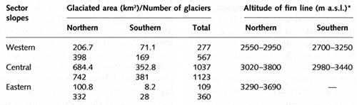
Table 15.1 Glaciers in the Greater Caucasus
Extensive plateaux, intermontane depressions, and valleys, associated with the ancient
drainage network, occur between 4000 and 4500 m providing ideal conditions for the
accumulation of snow and ice and the development of large glaciers of a branching mountain
valley type. Out of 215 mountain valley glaciers, known in the Caucasus, 130 occur in this
region. Seven glaciers, whose termini descend to 1800-2000 m, exceed 20-30 km in length
and 20-30 km2 in area, accounting for 40 per cent of the glaciated area of this
region. However, the largest glaciers develop on the volcanic cones of the Elbrus (123 km2)
and Kazbek (71 km2). Cirque and hanging glaciers are numerous in the central
Greater Caucasus and there are also a few surging glaciers. The most dramatic surges were
registered at the Kolka glacier, located on the northern slope of the Kazbek massif, in
1902 and 1969-70 when the size of the glacier increased by a factor of 6 (Rototaev et al.,
1983). In the western sector (where altitudes are lower) and in the eastern sector (where
precipitation is lower) cirque and small valley glaciers, with areas of about 1 km2,
prevail.
The north-facing slopes accommodate a majority of glaciers (61 per cent of all glaciers
accounting for 57 per cent of the glaciated area). There is also notable asymmetry in the
distribution of ice between the northern and the southern macroslopes. Although the
southern macroslope receives more precipitation, its steepness hinders the accumulation of
ice whereas the more gentle northern macroslope has twice as many glaciers. Glaciers,
located on the southern macroslope usually begin near the crest of the Glavny Ridge. On
the northern macroslope, glaciers often begin at lower altitudes in valleys of latitudinal
orientation located between the Glavny and the Bokovoy Ridges and in the spurs of the
Glavny Ridge. Strong insolation preconditions the occurrence of predominantly large
glaciers on the southern macroslope, while smaller glaciers develop on the northern one.
Current knowledge of the dynamics, structure, thermal regime, and mass balance of
glaciers is mainly limited to a number that have been selected as representative ones, and
have been monitored in the course of national and international research programmes. These
include the Maruh glacier in the western Greater Caucasus, the Bashkara, Shkhelda,
Dzhankuat, Bezengi, and glaciers of the Elbrus and Kazbek in the central Greater Caucasus.
With regard to the thickness of ice, radiosounding has shown that the thickness of typical
mountain-valley glaciers of average size (e.g., the Dzhankuat and Maruh) is about 100 m
(Tushinsky, 1968) while the depth of the Bezengi, the largest glacier in the Caucasus,
reaches 350 m (Macheret and Luchininov, 1973). The lack of information about the depth of
glaciers makes estimations of the total ice reserves in the Caucasus difficult. Using data
on 'typical' glaciers, Kotlyakov and Krenke (1980) estimate it as 120 km3 which
equals 100 km3 of fresh water. As for thermal regime, observations at the
Dzhankuat and Bezengi have shown that the temperature of the ice is close to 0°C
(Boyarsky, 1978; Panov, 1978). Below 3700 m, glaciers have numerous cavities filled with
liquid water and air (so-called warm glaciers) and a basal film of water which acts as a
lubricant enhancing their flow. Flow velocities vary between glaciers and different
domains in the same glacier (e.g., higher velocities are observed in the central part of a
glacier while at the sides the flow is slower because of friction) as well as seasonally.
Thus, average valley glaciers flow at 10-15 cm day-1 while the tongues of the
larger glaciers can move at 100-150 cm day-1. In summer, flow velocities at the
ice surface are 2-3 times higher than annual means (Panov, 1978).
In the Caucasus, the redistribution of snow by wind and avalanches and its accumulation
in troughs and cirques is as important for the development of glaciers as the amount of
snow precipitated on to its surface (Krenke et al., 1970). Thus, on the southern slope of
the Elbrus at an altitude of 3750 m, about 100000 tonnes a-1 of snow is
transported by wind across a 1 km distance normal to the direction of transport. Snow is
usually blown off the areas extending in the direction of prevailing winds and accumulated
on the glaciers oriented perpendicular to the prevailing wind. Large amounts of snow
accumulate in the windshadow (where snow depth may reach 20 m) and, because of it, the
depth of the firn (neve) can vary considerably even within one glacier. Typical of the
Glavny Ridge is the formation of vast 'snow walls' (steep slopes covered in snow) from
which large masses of snow slide on to the glacier surface. The Shkhelda and the Bezengi
glaciers receive a significant proportion of their nourishment via this mechanism.
However, the role of summer precipitation in the accumulation zone should not be
underestimated as summer snow compensates for the loss of mass to ablation. Kotlyakov and
Krenke (1980) estimate that, on average, the combined melt of the glaciers in the central
Greater Caucasus totals 2.2 km3a-1. The rate of melt is controlled
by two main factors: insolation and air temperature and the amount of diamict on the
surface of a glacier. While soiling of ice can change its albedo from 70 per cent to less
than 20 per cent, diamict can cover the ice, thereby protecting it from insolation. The
formation of sediment cover is especially typical where shales dominate the geology.
The mass balance of glaciers in the Caucasus exhibits complex temporal and spatial
variability. It varies inter-annually and on longer time scales and, according to
prevailing weather, glaciers can expand in one region or altitudinal belt and retreat in
another at the same time. Climatic conditions on the plains are not necessarily
representative of those in high mountains and historical climatic data, obtained for the
East European plain or even the foothills of the Caucasus, should not be taken as a proxy
source for climatic variability in the high mountains. Lichenometric surveys, radiocarbon
dating, and historical evidence have revealed that a relatively cold and wet climate
dominated the Greater Caucasus between the second half of the 13th and the beginning of
the 14th centuries (which is earlier than in other mountainous regions), and between the
17th and the 19th centuries, favouring glacial advance. During these periods, the
equilibrium line was positioned respectively 140-160 m and 50-100 m lower than now
(Serebryanny et al., 1978, 1984; Kotlyakov et al., 1991; Serebryanny and Solomina, 1995;
Krenke, 1995; Solomina, 1999). Glacial advance can result either from a decrease in
temperature or from an increase in precipitation, or from the combination of both factors.
Analysis of pollen spectra in the high mountains has shown that climate in the 13th-14th
centuries was not colder than it is now and glacial advance should be attributed to an
increase in precipitation (Serebryanny et al, 1978). The later stage of glacial advance
resulted from the combination of colder and wetter weather. Glaciers reached their maximum
extent in the 1680s, 1750s, and 1850s (Krenke, 1995; Solomina, 1999). Currently, glaciers
are in a state of retreat which began at the end of the 19th century, such as, for
example, the Dzhankuat glacier (Table 15.2).

Table 15.2 Variability in mass balance of the Dzhankuat glacier
Vinogradov et al. (1976) have estimated that between the 1880s and the 1970s, the
glaciated area has declined by 600 km2 (or 29 per cent) and 25 per cent of the
ice has been lost. The number of glaciers has increased by 31 per cent as a result of
disintegration of large glaciers. Deglaciation is more intense in those regions where
precipitation is less abundant and glaciers have been retreating faster on the northern
macroslope. The intensity of deglaciation also increases from west to east: while in the
western Greater Caucasus the glaciated area has declined by 21 per cent, in the central
and eastern sectors larger reductions of 30 per cent and 40 per cent have occurred
(Kotlyakov and Krenke, 1980).
The contemporary glacial retreat is not unique. Extensive degradation of glaciers
occurred in the Greater Caucasus between the 3rd and the 13th centuries. The retreat of
glaciers was so strong that this period is often referred to as 'the Arkhyz termination'
although it can be argued that 'termination' is not a valid term as glaciers declined but
did not disappear altogether. In many regions, the tree line was positioned higher than
now by 200-300 m and many mountainous passes were free of snow and ice: as glaciers
retreated during the 20th century, roads constructed at that time have emerged from under
the ice (Kotlyakov et al, 1973; Serebryanny et al, 1977; Solomina, 1999). There are still
many uncertainties about glacial fluctuations during the historical times: both temporal
and spatial extents of the 'Arkhyz termination' are disputed as well as the nature of
climatic change during this time. Thus, Tushinsky (1964) dates the beginning of the warm
stage to the 3rd century; Kotlyakov et al (1973) to the 6-8th centuries; and Turmanina
(1979) to the 8th century. Likewise, there is conflicting evidence about changes in
precipitation regime. For example, Turmanina (1988) interprets the occurrence of forests
and man-made terraces on the slopes of central and eastern Transcaucasia between the 8th
and the 12th centuries as evidence for a more humid climate than now, which was suitable
for the growth of forests and arable agriculture while reconstructing the contemporaneous
summer climate of the Elbrus region as warm and dry. The more humid conditions developed
in the region of Lake Sevan which exprerienced a transgression between the 10th and the
12th centuries (Solomina, 1999). By contrast, Grichuk (1980) reconstructs the climate of
Armenia between the 8th and the 13th centuries as dry and relatively cold while pointing
out that on the Colchis lowland this interval was complex, dry and warm between the 6th
and the llth centuries and humid later on. There are two possible explanations for these
discrepancies: first, climatic changes during the last millennium were not uniform across
the Caucasus and Transcaucasia and, second, the available chronologies are insufficient to
provide a complete picture of climatic change. Thus, although dendrochronology has been
recognized as one of the most successful methods of paleoclimatic reconstruction, there
are no more than twenty dendrochronologies available for the Caucasus and Transcaucasia
(Solomina, 1999). Most of those date back to the mid-19th century as this was the time
when the modern tree line began to form as glaciers were retreating while the ancient
timber was destroyed by the ice. However, most authors agree that there are three main
features of climatic and glacial fluctuations during the last thousand years: warming and
glacial retreat in the medieval period, glacial advance during the late 13th-early 14th
centuries and the 17th-19th centuries, and the current climatic warming and decline in
glaciation.
Glacial fluctuations in the Greater Caucasus during the earlier stages of the Holocene
have been studied by Serebryanny and his co-workers (Serebryanny et al., 1984).
Surprisingly little is known about the Pleistocene glaciations in the Caucasus. Perhaps
the most frequently quoted reason for poor knowledge of the Quaternary environments in the
mountains of the FSU is their remoteness and inaccessibility. However, the Caucasus is
neither remote nor inaccessible. It was studied extensively by many outstanding
geographers and geologists in the first half of the 20th century. Ironically, this
explains the lack of modern research. So fascinated were the early researchers of the
Pleistocene environments in the Caucasus by its similarity to the Alps that they
automatically accepted and applied the classic Penck and Bruckner model of the Pleistocene
glaciation to the Caucasus. So strong was their authority that this view has remained
unchallenged tor many years. As a result, the available reconstructions of
paleoenvironments in the Caucasus are mostly based on the traditional geomor-phological
approach. There are few radiocarbon dates and stratigraphies and chronologies are largely
unavailable for the mountainous regions (with a notable exception of the Holocene
stratigraphies established by Serebryanny and his co-workers for the central Greater
Caucasus). They are limited to the coastal regions instead.
The most complete Pleistocene stratigraphy of the Caucasus and the chronology, proposed
by Kozhevnikov and Milanovsky, are discussed in the volume The Quaternary System of the
USSR (Chetvertichnaya systema SSSR, 1984). Brief reviews of late Pleistocene environments
are provided by Serebryanny (1984) and Kozhevnikov et al. (1993).
<<< Modern Climate | Biomes & Regions Index | Environmental
Change and Evolution of Biota >>>
Contents of the Caucasus section:
Other sections of Biomes & Regions:
|
|


