Please put an active hyperlink to our site (www.rusnature.info) when you copy the materials from this page
Biomes and Regions of Northern Eurasia
The Mountains of Central Asia and Kazakhstan
<<< Earthquakes | Biomes
& Regions Index | Contemporary Climate >>>
Exogenic Processes and Main Types of Relief
Exogenic processes (e.g., mass movement, erosion, and frost weathering) play an
important role in the formation of relief and create a variety of landscapes. The relative
importance of exogenic processes is controlled by many different factors such as tectonic
activity and geology, altitude and topography, climate, the contemporary and Quaternary
glaciations, and human activities. Although environmental conditions and subsequently
landforms vary enormously between the individual ridges and slopes, there were many
attempts at geomorphologic regionalization of the mountains of Central Asia and
Kazakhstan. Differing in detail, all classifications emphasize a distinct presence of
various geomorpholog-ical zones in the mountains affected by orogenic uplift (Chedia,
1972). A scheme, providing the most broad geomorphological regionalization, which could be
applied to various mountainous systems of Central Asia and Kazakhstan, was proposed by
Kostenko (1966) who distinguished four geomorphological zones:
1. The inner zone of high elevation typical of which are ancient eroded surfaces formed
before the general upwarping of the region and elevated during the subsequent orogenic
event. Syrts of the central Tien-Shan, eastern Pamir, and denuded surfaces of the
Dzungarsky Alatau and Tarbagatay are representative of this group. Cryogenic landforms are
typical of the areas where permafrost develops.
2. The external mountainous zone typical of which is young alpine relief dissected by
intense water and glacial erosion. It is characterized by large relative elevations of 3-4
km, sharp peaks, deep, and narrow valleys and various glacial landforms. The mountains of
Badakhshan, western Pamir (the Academy of Sciences Ridge), and the massif Khan-Tengri in
the Tien-Shan belong to this group.
3. The foothills are characterized by moderately dissected relief with landforms formed
by denudation processes typical of the arid zone. In the Fergana valley, a local term adyr
is used to describe this hilly terrain with loess cover on the slopes being dissected by
ravines. This zone includes the foothills of the Tien-Shan and Kopetdagh, the hills of
Badkhyz and Karabil, and the slopes of the Fergana valley.
4. The inclined plains of the foothills, piedmont plains, and the intermontane
depressions are distinguished by the predominance of accumulative relief composed of the
material brought by rivers and mudflows. The inclined accumulative plains are typical of
the foothills of the Zailiisky Alatau, Kyrgyz Ridge, Kopetdagh, and Tarbagartay. In
depressions (e.g., the Fergana and Issyk-Kul), the proluvial plains are usually strongly
dissected. Aeolian landforms (sand dunes and hillocks) occur on the adjacent plains and in
the foothills, marking the transition to the desert landscapes.
Characteristic of the mountains of Central Asia and Kazakhstan is high instability of
slopes and intensive mass movements. The nature and intensity of slope processes are
controlled by various factors: seismic activity, geology, altitude, and aspect (which in
turn predetermine thermal and precipitation regimes), and human activity. The most typical
of the middle altitudes are screes which are often responsible for damming rivers. Another
hazard is avalanches. In the Tien-Shan alone, the area threatened by avalanches reaches
nearly 400 000 km2 of which over 280 000 are endangered every year and the rest
in years of abundant snowfall (Blagoveschensky and Seversky, 1996). The northern slopes of
the Terskey-Alatau are particularly prone to the formation of avalanches. In the
foothills, lower and middle mountains (800-2500 m), slopes are often composed of
uncon-solidated sediments, such as loess and loess loams, covered by sparse vegetation
which makes them susceptible to the formation of landslides and mudflows. They can be
triggered not only by seismic activity, but also by intensive rainfall and human impacts
such as deforestation and overexploitation of slope pastures. In the adyr zone and high
river terraces landslides can reach enormous proportions, transporting up to 2.5-3.5
million m' of mass over distance of a few kilometres (Fedorenko, 1988). On the
south-western macroslope of the Fergana Ridge, an area of 560 km2 is affected
by landslides and in southern Kygyzstan about 2 per cent of the territory, including a
considerable proportion of arable land, is lost to landslides (Rakhmanov, 1996). Aspect
controls over the relative importance of the contemporary geomorphological processes is
illustrated by Table 16.1.
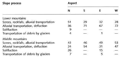
Table 16.1 Proportion of area (%) affected by various slope processes in
the Chon-Kyzylsu valley, Tien-Shan
This effect is particularly notable at lower altitudes, where sharp climatic contrasts
exist between south- and north-facing slopes. Thus, solifluction, which is controlled by
the freeze-thaw cycle, is typical of the north-facing slopes and does not develop on the
southern ones.
Strong dissection, sparse vegetation, loose rocks, and the large area of slopes provide
for the development of intense erosion which is further substantiated by the availability
of melt water from glaciers and a spring rainfall maximum (Plate 16.2).
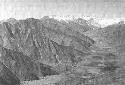
Plate 16.2 The upper Surkhob valley: rill erosion (photo: I.
Merzlyakova)
The highest erosion rates are observed in those areas when orogeny is most intense
(Alpatiev, 1976). Thus the rate of suspended material discharge in the Vaksh basin, where
the rate of uplift of the nearby ridges reaches 10-14 mm a-1, averages 2560
tonnes km-2a-1 while in the Talass and upper Naryn basins it
constitutes 20 and 80 tonnes km-2a-1, respectively (Figure 16.4).

Fig. 16.4 Intensity of denudation in Central Asia. After Shuits (1948)
Human activity is another important factor. In the complex terrain, where suitable land
is not widely available, slopes are used for all types of farming from the low impact
activities, such as production of hay, to the potentially damaging irrigation. During the
first half of the 20th century, before the intensive development of the region, only 10-15
per cent of arable land in the Pamir-Alay was affected by rill and surface erosion
(Merzlyakova, 1996). Protection measures (e.g., terracing, slope enforcement, and use of
specific crops) were successfully applied to prevent its development. However, since the
1960s the outmigra-tion of the rural population from the mountainous areas was encouraged.
Depopulation and abandonment of the fields have resulted in the poor maintenance of
terraces and irrigation furrows, and uncontrolled grazing. These factors, as well as the
construction of serpentine roads, which destroys vegetation cover on slopes, have led to
the more widespread formation of surface erosion and screes. As a result, about 70 per
cent of modern pastures in the Surkhob valley is affected by erosion; it has been also
estimated that about 40 per cent of modern wasteland in the valley was successfully
cultivated in the past (Merzlyakova, 1996). While it is notoriously difficult to provide
reliable general statistics on the extent and rates of erosion, particularly in the
complex mountainous terrain, an individual example may illustrate the growing human
impact. A gigantic ancient landslide near the town of Tajikabad was converted into arable
land and, through the control by terracing, used for many years without erosion developing
to any significant extent. In the late 1950s, the fields were abandoned and the
maintenance of the terraces ceased. By the early 1990s, most of the slope had become
strongly eroded badlands and the landslide was reactivated.
<<< Earthquakes | Biomes
& Regions Index | Contemporary Climate >>>
Contents of the Mountains of Central Asia and
Kazakhstan section:
Other sections of Biomes & Regions:
|
|


