Please put an active hyperlink to our site (www.rusnature.info) when you copy the materials from this page
Biomes and Regions of Northern Eurasia
The Mountains of Central Asia and Kazakhstan
<<< Exogenic Processes and Main Types of
Relief | Biomes & Regions Index | Environmental Change Since the Late Pleistocene >>>
Contemporary Climate
The mountains of Central Asia and Kazakhstan are located in the subtropical zone and at
the very south of the temperate zone close to the centre of the Eurasian continent. They
receive more insolation than any other region in the FSU but very little precipitation and
have an arid continental climate. Altitude and complexity of orography are other important
controls which force strong horizontal and vertical climatic variations across relatively
short distances. Climatic conditions, therefore, are discussed in general terms only
because climates of slopes with different aspects, locked-in basins, and exposed plateaux
can be vastly different. Due to their enormous height and extent, together with the
Tibetan plateau, the Pamir and Tien-Shan are themselves important controls over
large-scale atmospheric circulation (see above).
Across the region, there are strong seasonal variations in temperature. Winters are
relatively mild in the west and become more severe landwards (Figure 16.5). Thermal
conditions are also a function of altitude and exposure. In winter, the northern foothills
are affected by continental polar air masses, forming over Siberia and the plains of
Kazakhstan. However, usually the advection of cold air does not reach above 500 m and
typical of the foothills and lower mountains are strong temperature inversions, which
persist to an altitude of approximately 1500 m, and often make the foothills warmer than
the surrounding plains. The shielded locations, such as the Fergana valley, have mild
winters. Above 1500 m a normal vertical temperature distribution is restored. At an
altitude of approximately 2000 m winter temperatures are negative and in the enclosed
valleys the mean January temperature can be below -15°C. Exceptionally mild for its
location is the Issyk-Kul depression, whose climate is moderated by Lake Issyk-Kul which
remains unfrozen in winter. The mean January temperature of Przhevalsk, which is located
at 1774 m is the same as in Alma-Ata at 848 m (Figure 16.5). In summer continental
tropical air masses (which form over the Iranian plateau and the Turanian plain) dominate,
producing hot and dry weather in the low mountains. Generally, seasonal thermal contrasts
become less marked with altitude as air becomes more humid, cloudiness increases, and
precipitation becomes more abundant. However, on the highly elevated plateaux the annual
temperature range can be even higher than at the same longitude in the foothills. Thus in
Khorog, which is situated at a height of 2100 m, the annual temperature variation exceeds
30°C.
Moisture is delivered to the mountains of Central Asia and Kazakhstan mainly by the
westerly flow but the moisture content of the Atlantic air masses is depleted. Although
the Caspian supplies as little as 5 per cent of the moisture received by the mountains, it
influences precipitation through the combined effect of additional water vapour and
conditional instability in the lower atmosphere. Evaporation from the Caspian accounts for
about 40 mm of precipitation received by the northern slopes and for 10-20 mm received by
the interior mountains (Lydolph, 1977). A precipitation maximum occurs in March-April when
the Iranian branch of the Polar front passes over the mountains migrating further north in
May (Figure 16.5). In the eastern Pamir, which is affected by the Asian monsoon, a summer
precipitation maximum is recorded.
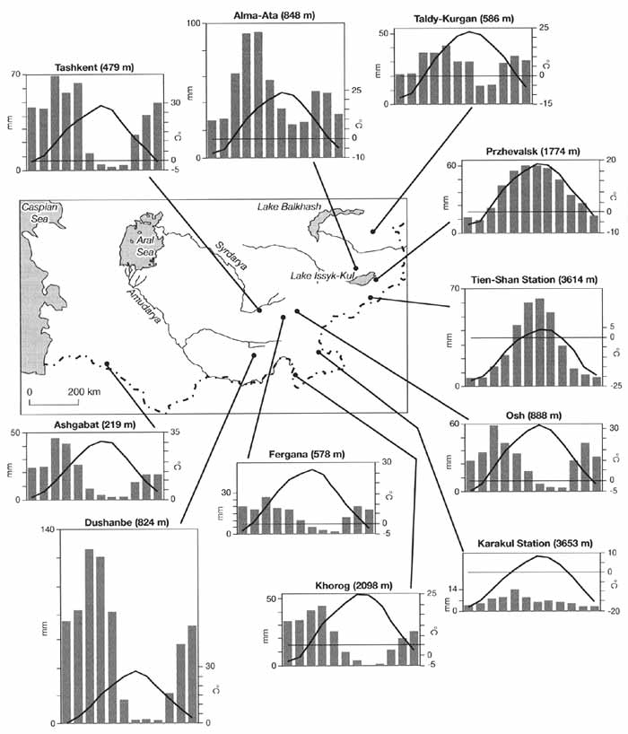
Fig. 16.5 Mean monthly temperatures (°C) and precipitation (mm) in the
Central Asian mountains
The belt of maximum precipitation is located between 2000 m and 4000 m, although the
vertical pluvial gradients differ between slopes (Table 16.2).
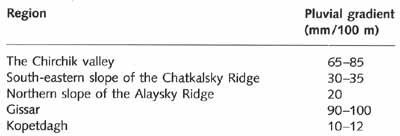
Table 16.2 Vertical pluvial gradient in the Central Asian mountains
Local topography has a very strong control over the spatial distribution of
precipitation through the orographic uplift and blocking. Heavy precipitation is
associated with the development of a synoptic situation known as an orographic occlusion
of a weather front (Figure 16.6).
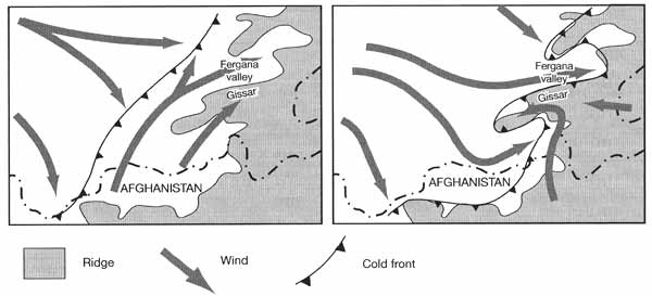
Fig. 16.6 Schematic representation of orographic occlusion in the
Pamir-Alay. Modified from Lydolf (1977)
The predominant latitudinal orientation of ridges and their fan-shaped divergence to
the west allows the westerly flow to penetrate deep into the valleys. The flow is
channelled through the valleys and condensation of moisture takes place on the slopes in
their western sections. Thus, while the Fergana valley has an arid climate, the upwind
slope of the Fergana Ridge receives about 800 mm of precipitation at an altitude of 1200 m
and the Gissar Ridge receives over 1500 mm. The western slopes of the north-south
orientated ridges benefit most from the Atlantic moisture. Where such ridges attain a
considerable height, the development of extensive permanent snow fields and glaciers takes
place such as, for example, on the western slope of the Academy of Sciences Ridge. The
north-south orientated ridges intercept most of the moisture brought from the west and the
interior mountains are dry despite their enormous height. While the western Pamir receives
300-600 mm of precipitation, the eastern Pamir is one of the driest regions in the FSU. In
the basin of Lake Karakul and the Murgab valley, mean annual precipitation does not exceed
100 mm. Large lakes further complicate the spatial distribution of precipitation. Thus,
the western part of the Issuk-Kul valley receives about 100 mm of precipitation per annum
while the eastern sector receives about 400 mm due to the moderating effect of the lake.
Controlled by orography is the local wind regime and both mountain-valley winds and
fohns are typical, extending to an altitude of 2-2.5 km. Fohns are most frequently
observed between November and April when they are forced by cyclonic activity. Associated
with southerly and south-easterly winds forming ahead of the depressions advancing from
the south-west, winter fohns are particularly common on the northern slopes, where their
velocity often exceeds 20 m s-1. In the regions of Tashkent and Ashgabat,
during fohn events air temperature rises above +22°C in December (Borisov, 1965; Lydolf,
1977). The fohn often drives snow away (evaporation of snow is not unusual since the
relative humidity can drop from 70-90 per cent to 10-20 per cent) and maintains warm
weather for a few consecutive days even in the middle of the winter, which allows
mountainous pastures to be used throughout the year. During the warm part of the year
between March and October, fohns can damage crops although more frequently in summer the
descending air is usually not much warmer than the air in the foothills. Locally, the
strong fohns are known as harmsil, hot and dry wind. A variety of local circulations
develop in the mountains of Central Asia and Kazakhstan, particularly in the Fergana and
Issyk-Kul valleys and in the north-eastern foothills of the Dzungarsky Alatau (Lydolf,
1977, provides a detailed review).
The proximity of high mountains and deserts accentuates the role of local circulations
in the transportation of dust. The afganets, a characteristic post cold-frontal wind
usually of westerly or south-westerly direction, brings dust storms after passing over the
southern Karakum into the upper reaches of the Amudarya and in southern Tajikistan,
occasionally reaching into the Vaksh valley. The aeolian transfer of solid matter from the
mountains to the plains accounts for 6 x 10⁸ tonne a-1 while 1 x 10¹³ tonne a-1
is transported in the opposite direction (Alibekov, 1997). Currently, an increase in the
aeolian transfer of dust and salts to the mountains is observed mainly due to the
regression of the Aral Sea (see below). Annually, about 43 million tonnes of dust is
transported from the exposed bottom of the Aral Sea and partially deposited in the
mountains (Rubanov and Bogdanov, 1987).
The relatively mild climate in the low and middle mountains (Table 16.3) provide
conditions for farming where water is available.
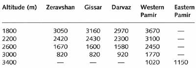
Table 16.3 Annual accumulated temperatures at various altitudes (using
daily mean of 10°C as a reference temperature)
The altitude of the upper boundary of arable agriculture varies across the region in
line with the availability of thermal and moisture resources, being on average 700-1000 m
lower in the Tien-Shan than in the Pamir-Alay where it extends to 3500-3800 m (Chelpanova,
1963). Thus, the upper boundary of cotton growing extends to 850-1000 m in the western
Tien-Shan and the Fergana valley, rising to 1000-1200 m in the Pamir-Alay and Kopetdagh
(Table 16.4).
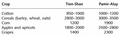
Table 16.4 Altitude (m) of the upper boundary of cultivation of various
crops in the Tien-Shan and Pamir-Alay
In Central Asia, arable farming extends higher into the mountains than anywhere else in
the FSU. For example, in the Caucasus its upper limit does not exceed 1800-2000 m.
<<< Exogenic Processes and Main Types of
Relief | Biomes & Regions Index | Environmental Change Since the Late Pleistocene >>>
Contents of the Mountains of Central Asia and
Kazakhstan section:
Other sections of Biomes & Regions:
|
|


