Please put an active hyperlink to our site (www.rusnature.info) when you copy the materials from this page
Biomes and Regions of Northern Eurasia
The Far East
<<< Climate | Biomes
& Regions Index | Sakhalin >>>
The Maritime Province
Encompassing the Sea of Japan coast, the Sikhote-Alin mountains, and the Khanka
lowland, the Maritime Province represents a combination of mountains and plains with about
three-quarters of the region being occupied by mountains.
Geomorphology and Environmental History
A major physical-geographical unit of the Maritime Province is the Sikhote-Alin
mountainous system which extends along the Sea of Japan coast for 1100 km. Three major
stages are identified in the geological history of the Sikhote-Alin-Sakhalin fold belt
(Zonenshain et al., 1990). The first stage began in the late Paleozoic and continued
throughout the Mesozoic. It includes the pre-flysh deformations which occurred in early
Cretaceous time. The next, much shorter stage commenced thereafter and ended with the
deformation of the Sikhote-Alin folded structures before the Senonian age of the late
Cretaceous as the Sikhote-Alin island arc collided with the Amur Plate. The third stage
(which is continuing) began at the end of the late Cretaceous when the continental margin
affiliation of the Sikhote-Alin belt became established and the arc became a part of the
newly constructed margin of Eurasia. High seismic activity is typical of the Sikhote-Alin
with earthquakes reaching 8 points on the Richter scale.
The average elevations in the Sikhote-Alin range between 800 and 1000 m and only two
peaks (the Tardoky-Yany and Ęî) exceed 2000 m. There is no clearly expressed axial ridge
and the main watershed has approximately the same altitudes as its spurs. The Sikhote-Alin
has an asymmetrical shape: the eastern macroslope is more steep, narrow, and dissected
than the western one. The dome-shaped tops and convex upper slopes result in a landscape
formed by eroded hills and steep alpine relief is almost absent. The Sikhote-Alin can be
divided into two parts: the 200-250 km wide mountainous system and the adjacent
approximately 60 km wide coastal section. Intensely dislocated Paleozoic clay shales,
sandstones, and limestones are exposed in the axial zone while the periphery is formed by
younger Mesozoic sandstones, aleurolites, claystones, and effus-ives and tuffs. High peaks
are mostly associated with granite intrusions exposed by denudation. In the lower
Pleistocene, extensive outpouring of andesitic-basaltic lavas took place. Thick deposits
reaching 200-250 m occur on the interfluve of the middle Sikhote-Alin while in the upper
course of the Ussuri these lavas form remarkably uniform and flat elevated plateaux.
Typical of the Sikhote-Alin are intermountain depressions associated with ongoing
subsidence and filled with sandy-clayey Neogene continental deposits. Despite modern
tectonism, the contemporary denudation rates are relatively low because of the
well-developed sod and vegetation cover. Only in those areas where vegetation has been
degraded do slopes deteriorate significantly. Perhaps the most active modern
relief-forming processes are those related to physical weathering in the upper mountains,
which are devoid of vegetation, and to solifluction in areas of permafrost occurrence.
Typical of the coastal section are Cenozoic lavas and tufts overlain by basalts. The
mountains break off near the shore in cliffs and abrasion and abrasion-denudational forms,
which coincide with faults, prevail in its northern part. Zones of abrasion are
occasionally broken by mouths of the mountain rivers but because the Sikhote-Alin runs
parallel to the shore northwards of the Bay of Olga, the coast is cliffed and there are
few bays. Some of the existing ones have been formed from eroded volcanic calderas (Kaplin
et al., 1991). By contrast, the southern segment has a typical ria coast. The mountain
ranges run perpendicular to the coastline and numerous bays, deep estuaries, and islands
have been created during marine transgressions. The formation of the contemporary
coastline began in the late Pleistocene and since then the relative importance of abrasion
and accumulation has been alternating (Korotky, 1988). Thus, during the latest
interglacial, the sea level rose by 8-10 metres compared to the contemporary sea level and
intensive coastal abrasion developed. During the last glaciation, extensive regression of
the Sea of Japan took place with the sea level lowering by 110-130 m during the glacial
maximum. The formation of marine terraces and intensive accumulation of slope sediments
dates back to this period. The middle Holocene (5-2.5 Ka BP) was characterized by another
transgression and the rise of sea level by 2-3 m compared to the present one which has led
to the formation of the rias in the southern Maritime Province, development of the
youngest abrasional segments, and transformation of denudation surfaces into abrasional
coastal forms. At present, abrasion segments of the coast are relatively stable while the
accumulation segments are being eroded because the sedimentation is weak.
Another major unit is the Khanka lowland, a 100-120 km wide, low, and flat tectonic
depression situated between the East Manchurian mountains and the Sikhote-Alin. The
lowland developed during the Neogene-Quaternary when marine transgression, formation of
lakes and slow river flows resulted in the accumulation of lacustrine and alluvial
deposits and filling of the depression. Because of the continuing subsidence and poor
drainage, ground water levels are high and the lowland is extensively swamped (Yarmolyuk,
1969). The large (4190 km2) but shallow (maximum depth llm) Lake Khanka
occupies the central part of the lowland. A vast water body formed on the Khanka lowland
in the Pliocene and the first lacustrine deposits date back to about 10 Ma BP. More
recently (during the last million years) frequent and extensive oscillations in lake level
and area have occurred and at present the lake level is known to oscillate every twenty
six years (Vaskovsky, 1978).
Ecology
Located at the junction of four botanical regions, the Maritime Province is
distinguished by a high biological diversity. The history of vegetation development and
its diversity are best manifested in its complex composition distinguished by a
combination of boreal, temperate, and subtropical species. Heat-loving elements of the
Manchurian flora (various broad-leaved woody species and vines) have advanced to the
region from the south reaching approximately to 50°N; species representative of the
Okhotsk flora (e.g., Picea ajanensis) have migrated from the north; elements of the
frost-resistant East Siberian flora (e.g., Larix gmelimi widespread in the northern
Maritime Province) have arrived from the north-east; and the steppe Dahurian (Mongolian)
species have penetrated from the Transbaikal region through the Khanka lowland. In
contrast to many other regions, the Quaternary glaciation in the Maritime Province was
limited to the high mountains and the evolution of biota has been continuous throughout
the Neogene-Quaternary. Many warmth-loving Tertiary species (representatives of the
Manchurian flora) have survived such as, for example, Phdlodendron amurense and Aralia
mandshurica, while many boreal species invaded during the cold epochs (Kolesnikov, 1969).
Further complexity arises from the climatic factor and topography: the Maritime Province
encompasses three natural zones (dark taiga, mixed broad-leaved coniferous forests and
forest-steppes also known as the Amur prairies) the continuity of which is disrupted by
the influence of the ocean and mountainous relief. A combination of these factors have
created a complex and unique biota which is distinguished by many endemics and does not
have an analogue in the FSU (Ablaev, 1978).
The most prominent zonal vegetation is the mixed broad-leaved coniferous forest of the
Manchurian type which occurs on the plains of the southern Ussuri region and covers lower
slopes in the southern Sikhote-Alin. Over 100 species are Tertiary relicts and endemics
and the total number of woody plants exceeds 200 (Taiga dalnevostochnaya, 1986). The
forests are polydominant and have a complex multitier structure. The first tier is
composed of tall conifers which, being 250-300 years old, exceed 40 m in height and 200 cm
in diameter. The most common species are Pinus koraiensis and Abies holophylla. A tier of
deciduous trees, composed of Betula costata, Tilia amurensis, Ulmus montana var.
heterophylla, Acer mono, and Jugltms mandshurica, develops below the canopy of conifers. A
particularly valuable species is Phellodendron amurense which adapts easily to severe
climatic conditions, is drought-resistant and can be cultivated in more northern regions.
The third tier comprises Carpinus cordata, Tilia mandshurica, Acer mandshuricum, Primus
maximowiczii, and Syringa amurensis while the undergrowth consists of many shrubs. Vines
are abundant in the Manchurian forests, growing best in lighter habitats such as river
banks and areas damaged by fire. The most common species are Vitis amurensis, Schisandra
chinensis known for its strong lemon-like scent, the largest and most heat-loving vine
Actinidia arguta, and the most abundant and northern-growing Actinidia kolomicta. On the
well-drained southern slopes, dense Quercus mongolica-Pinus koraiensis-Betula dahurica
forests develop as well as groves of Quercus mongolica which replace mixed communities
destroyed by fire. Taxus cuspidata occurs in the southern Sikhote-Alin. The mixed and
broad-leaved forests of the Maritime Province are also discussed in Mixed
and Deciduous Forests section.
The southernmost Maritime Province and the Khanka lowland are occupied by vegetation
communities known as the East Asian savannahs or the Amur prairies (Kolesnikov, 1969).
These resemble the chernozem steppes but the excess of summer moisture prevents the
formation of chernozem and soils with a high content of humus (reaching 15 per cent) and
traces of gleying develop instead. Three main types of vegetation occur in the Amur
prairies: woodlands, meadow steppes, and wetlands. Most researchers believe that all these
are primary communities the origin of which dates back to the middle Pleistocene. The
modern distribution of vegetation communities is controlled by soil moisture which in turn
depends on topography. Woodlands develop in well-drained elevated sites and slopes and are
composed of adapted low growing Quercus mongolica and Betula dahurica with Corylus
heterophylla and Lespedeza bicolor in the shrub tier and grapevines. Natural woodlands
degraded by human activity are replaced by shrub thickets. Most of the interfluves are
covered by meadow steppe communities whose distribution is clearly marked on the Khanka
lowland. Cereal-grass meadows with scattered individual trees occupy drier parts of the
plains and there are many Dahurian species in the driest slope habitats underlain by sand
and gravel. Mixed-grass meadows dominate habitats with moderate moistening and reed grass
meadows occur in moist but not permanently swamped sites. Highly productive fens,
dominated by tall grasses and sedges, occupy low and wet habitats. The shores of Lake
Khanka are largely swamped and vegetation here is formed by such species as Phalaris,
Typha pallida, Scirpus, and Zizania latifolia and many warmth-loving aquatic plants (e.g.,
Euryaleferox and Salvinia natans). Lake Khanka is located on the migration route of many
bird species. Its bird fauna includes more than 200 species and the lake is protected
under the Ramsar convention.
Altitudinal differentiation is well expressed in the distribution of vegetation in the
Sikhote-Alin (Ogureeva, 1999). The southern Sikhote-Alin, where summers are long, warm,
and humid, is distinguished by an intricate vertical zonality (Figure 18.2).
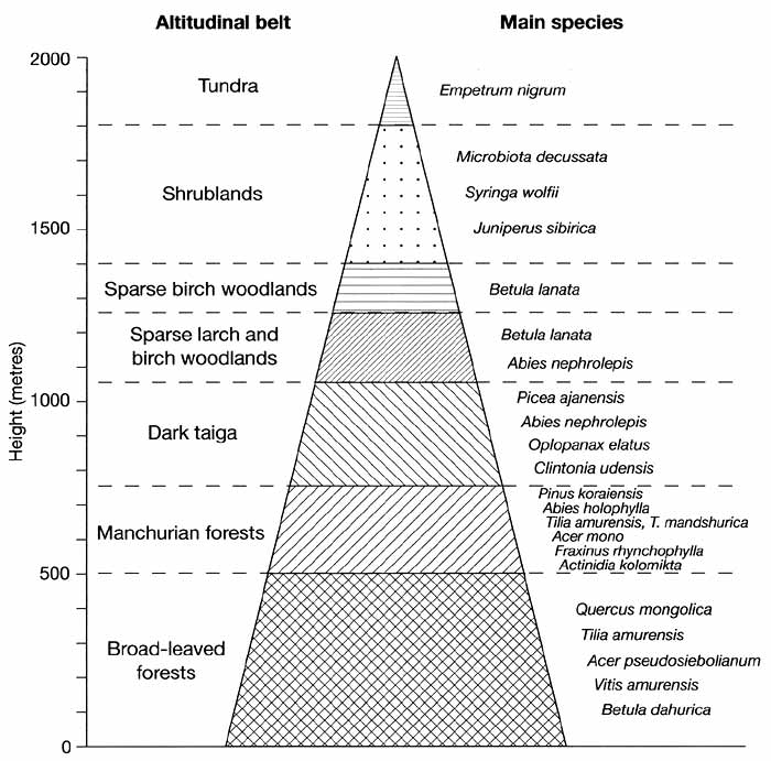
Fig. 18.2 Vertical vegetation zonation in the southern Sikhote-Alin.
Data from Ogureeva (1999)
The Manchurian forests occupy the foothills and lower mountains passing into the dark
taiga which contains mainly Okhotsk species above 750 m. Close to the timber line,
coniferous forests alternate with Betula lanata woodlands. Above 1400 m, these are
succeeded by open landscapes where vegetation is represented by shrublands of Microbiota
decussata and Pinus pumila alternating with mountainous tundra communities and bare rocks.
The upper limit of the mixed forest belt lowers northwards and the composition of forests
changes: while in the south most widespread are the mixed Abies holophylla broad-leaved
and Pinus koraiensis-Carpinus cordata forests with vines, further north these grade into
Pinus koraiensis broad-leaved and Picea ajanensis broad-leaved forests. North of 47° and
50°30' latitude on the eastern and western macroslopes respectively, these are almost
completely replaced by the dark taiga dominated by Abies nephrolepis and Picea ajanensis.
The asymmetry is related to the cold current flowing from the Sea of Okhotsk through the
Tatar and La Perouse Straits (Figure 18.1) that pass close to the shore, reducing the
water temperature by 10-11°C, which results in a cooler climate.
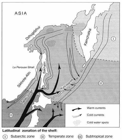
Fig. 18.1 A sketch map of the Far East
Mixed forests, devoid of many southern species, do not form a continuous belt,
developing only locally in favourable habitats. The floristic composition of the taiga is
much poorer: total species number is small compared to the mixed forests and there is
little undergrowth. Since the beginning of the 20th century it has been known that
approximately every 25 years the Picea-Abies forests undergo severe degradation leading to
the widespread death of forests (Manko, 1967; Kozin, 1986). Initially, this process
affects mature uniform stands but it may later spread to younger trees. Although this is
believed to be a part of the natural cycle of coniferous forest development and ageing,
human activities often exacerbate its extent and intensity (Gladkova et al., 1993). The
protective role of these forests is very important because soil cover in the northern
Sikhote-Alin is thin and may be easily washed off by melt water and summer rains. The
sparse Larix forests, similar to those of Eastern Siberia, develop in habitats underlain
by permafrost.
The continuity of evolution and a high diversity of habitats have resulted in a rich
and unique fauna which includes both southern and boreal species. Of these the Amur tiger,
which inhabits the mixed forests, attracts most interest. Due to overhunting, tigers
nearly disappeared in the 1930s-1940s, when their population was reduced to about 40
individuals and only strict conservation measures have allowed them to increase their
number to about 400 (se below; Strategy for Conservation, 1996). At present, natural
conditions of the Far East do not limit the development of this species and the only
negative factors are poaching aimed directly at the Amur tiger and ungulates forming its
trophic base, and the destruction of habitats through deforestation.
Environmental Management and Nature Protection
The degree of anthropogenic pressure varies across the Maritime Province and while some
areas, such as sections of valuable forests in the Sikhote-Alin, are conserved, other
regions experience considerable human pressure. The main activities damaging the
environment are timber logging, mining, and agriculture. The most impacted area is the
southern coast of the Sea of Japan, where the large ports of Vladivostok and Nakhodka are
located and polymetallic deposits are developed, and the lowlands of the southern Maritime
Province, which are important agricultural regions. Although arable land constitutes only
10 per cent of the total Maritime Province area, 40 per cent of the Khanka lowland is
cultivated. The direct withdrawal of land for agriculture, land reclamation, and water
pollution cause degradation of Lake Khanka's environment and threaten its wildlife
(Bogatov, 1996). However, it is deforestation that is most damaging to ecosystems in
general and biological diversity in particular. Commercial logging peaked in the early
1990s when about 8 million m3a-1 of coniferous forest was cut in the
Sikhote-Alin leading to a 70 per cent reduction in the area of cedar forests in comparison
to the 1920s (Dolgovremennaya progmmma, 1992). Although the affected territory is not
large in comparison with the total forested area of the Maritime Province (75 per cent of
which is forested), the extraction of valuable species as well as the use of degrading
methods (see below) have lowered the capacity of forests for natural regeneration and
changed the composition of forests dramatically. In particular, clear felling, which is
commonly used, has led to the replacement of primary forests with Ouercus mongolica and
Lespedeza bicolor shrublands which have spread across the foothills and lower mountains
forming locally a continuous vegetation belt (Figure 18.2). The need for protection of
forests and wildlife is widely recognized both by Russian and international conservation
bodies and at present there are eight nature reserves in the Maritime Province. One of
them, the Sikhote-Alin, has the status of a biospheric reserve and is included in the
UNESCO World Nature Heritage List. Protected areas occupy 7 per cent of the total
territory and an expansion to 15 per cent is planned by 2005 so that various habitats are
included and a general ecological balance is sustained (Dolgovremennaya programma, 1992).
<<< Climate | Biomes
& Regions Index | Sakhalin >>>
Contents of the Far East section:
Other sections of Biomes & Regions:
|
|


