Please put an active hyperlink to our site (www.rusnature.info) when you copy the materials from this page
Russian Zapovedniks and National Parks
<<< Zapovednik "Koryaksky" | Index and Map | Zapovednik "Kurilsky"
>>>
Zapovednik "Kronotsky"
Address: 684010 Kamchatskaya obl., Elizovo, Riabikova st., 48.
Zapovednik Kronotsky, in the southern part of Kamchatskaya Region, was founded in 1934,
but it did not function in 1951-1959 and 1961-1967. Its area is 1142 thousand ha; of which
135,0 thousand ha is accounted by the water area.
It is located on the eastern shore of the Kamchatka Peninsula and is bordered by
natural boundaries — the rivers Chazhma and Semiyachik, the Pacific Ocean shore, and the
Valaginsky Ridge.
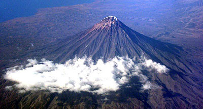
Lake Kronotskoe is situated in the inter-mountain depression. A chain of 16 volcanoes
goes along Kronotskoye Lake; the highest of them is the dome of Kronotskaya (3526 m above
sea level). In the eastern part of the Zapovednik mountains are lower (up to 1400 m above
the sea level); mountain-glacier landscapes are widely present here. The greatest of the
glaciers (Tyushevsky) reaches 8 km in length.
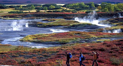
The network of rivers and streams is dense — one each 100 ha of area. There are 650
rivers and streams, on average, are located. The Zapovednik has a unique natural feature
— the "Valley of Geysers". Along 6 km of the valley of the river Geysernaya at
the foot of Kikhpinych volcano 22 big geysers function.
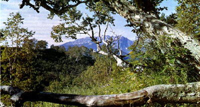
With changes of height several landscape belts can be seen — sea shore, forests, bush
thickets, and forestless highlands. Near the shore line sites of bushy and moss tundras
are met. Forests are composed mostly of birch wood-meadows of Betula ermanii.
Among rare communities in the Zapovednik are plantations of Chosenia and Populus
komarovii. There are isolated forest sites of Dahurian larch (on the northern coast of
Kronotshoye Lake), and a grove of Abies sachalinensis (on the lower parts of the river
Stary Semiyachik).
Flora accounts for 810 plant species, including 38 which are endemic. Groups of
Fimbristulis ochotensis, true mosses, Agrostis scabra, Lycopus, and sometimes — of
Ophioglossum thermale are especially notable.
The animal world is formed of representatives of taiga and tundra fauna with some
steppe species (Citellus parryi, Marmota camtschatica). Widely spread subspecies are often
present with larger than usual and more darkly colored (the Okhotsky subspecies of wild
reindeer, Kamchatka subspecies of sable, Kamchatka brown bear, etc.). The Zapovednik is
distinguished by its very high density of brown bear.
At the sea shore sea bird and sea animal communities are located. In the lakes and in
near-sea tundras numerous waterfowl nest. Of rare and disappearing animals in the Red Data
Book of the Russian Federation there are met: sea beaver, Steller’s sea eagle, fish
hawk, Arctic Falcon, and Aleutian tern.
The Zapovednik has biosphere status. It integrates the South-Kamchatka Federal Nature
Zakaznik under its jurisdiction; the zakaznik was founded in 1983 on an area of 225,0
thousand ha.
It belongs to the World Natural Heritage Site "Volcanoes of Kamchatka".
<<< Zapovednik "Koryaksky" | Index and Map | Zapovednik "Kurilsky"
>>>
|


