Please put an active hyperlink to our site (www.rusnature.info) when you copy the materials from this page
Biomes and Regions of Northern Eurasia
The Arctic Environments
<<< Introduction | Biomes & Regions Index | The Climate of
the Arctic and Ice Conditions in the Arctic Seas >>>
The Arctic Oceanic Shelf
The Arctic Ocean consists of a deep basin, submarine ridges, continental shelves, and
marginal plateaux (Figure 8.2).
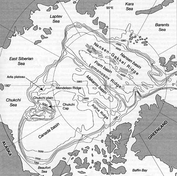
Fig. 8.2 Overview map of the topography of the Arctic Ocean. Modified
from Weber (1990)
Five major seas — the Barents, Kara, Laptev, East Siberian and Chukchi — are
located at the wide and shallow European and Siberian shelves which occupy about 35 per
cent of the entire ocean and contain only 2 per cent of the total volume of water (Pickard
and Emery, 1990). The shelves are limited by the Greenland Sea in the west and Chukchi
Borderland (comprised by Arlis plateau and Chukchi Cap) in the east. The Eurasian basin is
dissected by the Nansen-Gakkel and Lomonosov Ridges. The active Nansen-Gakkel Ridge is
1500 km long, rises 2000 m above the sea floor and has a complex topography suggestive of
numerous faults and fracture zones (Weber, 1990). The Lomonosov Ridge, which rises 3000 m
above the sea floor and extends for 1800 km, was discovered by Soviet scientists in 1948
to the disappointment of the Americans who, unaware of the Soviet exploration,
'rediscovered' the ridge a few years later (Worthington, 1953).
The Barents sector of the European shelf is limited in the east by Novaya Zemlya and
the St. Anna trough and in the west by the Fram Strait and the Norwegian Sea, which
connects it with Atlantic waters. The depth varies between 100 m and 350 m except in the
Bear Island trough where it reaches 500 m (Weber, 1990). Bottom topography is complex with
many submerged ridges, banks, and depressions. Two terraces related to the last two
glaciations occur at about 200 m and 70 m (Klenova, 1966). The submerged slopes between 70
m and 200 m are dissected, which testifies to a long history of subaerial erosion, while
the younger level has smoother relief. Meagre river runoff, which goes mainly into the
fjords of the Kola peninsula and Novaya Zemlya delivers small quantities of sediment; silt
discharge is reduced by permafrost and winter freezing of the rivers.
The Siberian shelf is one of the world's widest and is shallow. The Chukchi sector,
which occupies about 900 km2 between Barrow Sea Valley and Wrangel island, is
characterized by low bathymetric gradients. The East Siberian sector is a flat and shallow
plain approximately 800 km2 wide; the western and central parts of the sea are
only 10-20 m deep and in the east the depth reaches 30-40 m. The shelf is dissected only
by the Indigirka and Kolyma submerged river channels. Topography of the shelf was shaped
mainly by subaerial erosion during the sea retreat as well as by fluvial sedimentary
discharges (Weber, 1990). The formation of subsea permafrost also dates back to the period
of marine regression. Topography of the Laptev sector comprises numerous submarine valleys
of erosional and tectonic origin (Holmes and Creager, 1974). The erosional features were
formed at the end of the Pliocene and the beginning of the Pleistocene when the sea level
was lower than at present. In the lower and middle Pliocene, under conditions of rising
sea level, the previously eroded valleys were partially buried (Ionin, 1966).
Sedimentation is high due to the discharge of suspended matter by the rivers Lena (on
average 11.3 million t a-1) and Yana (6.2 million t a-1) and leads
to the formation of shallows and banks in the nearshore areas. River sediments are
transported by turbidity currents across the sea to be deposited at the eastern edge of
the Nansen-Gakkel Ridge. The Kara sector, which is about 100 m deep, is occupied by a
series of terraces descending in northern and western directions (Fairbridge, 1966).
<<< Introduction | Biomes & Regions Index | The Climate of
the Arctic and Ice Conditions in the Arctic Seas >>>
Contents of the The Arctic Environments
section:
Other sections of Biomes & Regions:
|
|


