Please put an active hyperlink to our site (www.rusnature.info) when you copy the materials from this page
Biomes and Regions of Northern Eurasia
The Mountains of Central Asia and Kazakhstan
<<< The Caucasus: Conclusions | Biomes & Regions Index | The Formation and
Morphology of the Mountains >>>
Introduction
This chapter deals with the mountainous systems of Central Asia within the boundaries
of the former Soviet Union (FSU). The mountains extend from west (the Kopetdagh) to east
(the Dzhungarsky Alatau) for more than 35° of longitude and from north to south for 10°
of latitude. Three main mountainous regions are distinguished within the area: the
Tien-Shan and Pamirs (which are often subdivided into the Pamir-Alay and Pamir) separated
by the Fergana valley, and the Kopetdagh separated by the Tajik depression (Figure 16.1).
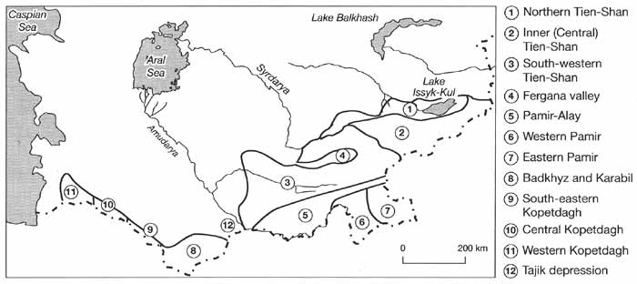
Fig. 16.1 Regional division of the Central Asian mountains
Not only is the Fergana valley an important orographic divide, formed by tectonic
subsidence, but it is also an important climatic and biogeographical boundary. Detached
from the main system of the Tien-Shan are the mountains of Dzhungarsky Alatau, Saur, and
Tarbagatay.
In the FSU, two terms are used with respect to this area: Central Asia and Middle Asia.
The term Central Asia is used in a political and administrative context as a reference to
the republics of Turkmenistan, Tajikistan, Uzbekistan, and Kyrgyzstan. In the physical
geographical context, the region is known as 'Middle Asia' while 'Central Asia' refers to
Dzhungaria, the Takla-Makan, and Gobi. The term 'Central Asia' is used in this chapter
because it is how the region is known worldwide.
The first information about the mountains of Central Asia dates back to the writings of
Arrian, Strabon, and Ptolemy and works of the oriental encyclopaedists Biruni, Makhmud
Kashgari, Muhammad Khorezmi, and Babur (Sinitsin, 1959). Systematic studies of the area,
known then as Turkestan, began with the colonization by the Russians in the 19th century.
Many expeditions were undertaken by the outstanding geographers and explorers: Semenov
(whose name was later changed by the order of the Tsar to Semenov-Tien-Shansky in
recognition of his achievements), Zarudny, Mushketov, Severtsev, Fedchenko, Obruchev,
Berg, and Korzchenevsky.
Already the early explorations uncovered and substantiated the major features of the
Central Asian mountainous systems and their unity as a physical geographical formation.
Three major factors control the environment of the region: (I) altitude — five peaks are
over 7000 m high (the peaks of Communism — also known as Garmo, Lenin, Pobedy, Kongur,
Muztagat) and the Khan-Tengri is only five metres below the mark; (II) southern location
within the desert biome; and (III) continentality of climate. Locally, the orographical
layout and aspects play an important role in the differentiation of the montane
environment. Most ridges extend from west to east being divided by longitudinal valleys.
There are also ridges with submeridional orientation, such as Fergana, Ak-Shyirak, and
Academy of Sciences (Figure 16.2).
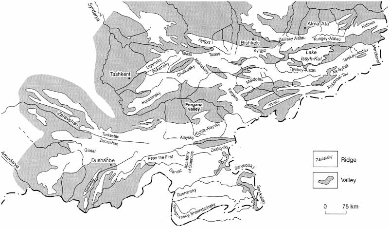
Fig. 16.2 Orographic map of the Central Asia
Typical of the Central Asian mountains is the absence of a continuous forest belt in
altitudinal zonation, the predominance of desert and steppe ecosystems in the foothills
and low mountains and at considerable height, and extensive glaciation. Over 20 000
glaciers with the combined area of over 16 000 km2, which accounts for 70 per
cent of all alpine glaciers of the FSU, are located in the mountains of Central Asia
(Kotlyakov, 1984). The climatic diversity and complex orography control the originality
and variety of biota. Species of the Indo-Himalian, Mongolian, Central Asian, and Eurasian
flora and fauna coexist, having penetrated into the region at different times and by
various routes. The mountains are one of the world's centers of biological diversity and a
centre of the original domestication of many cultivated plants such as, for example, rye
and pea (Agakhanyants, 1981).
The mountains of Central Asia and Kazakhstan exert a strong influence on the
environments of the adjacent plains. Rivers, which play a key role in the agricultural
development of these arid lands, originate in the mountains. The river regime is
favourable for irrigation (high water occurs in summer when it is needed most by crops)
and irrigation systems are known to have existed in Central Asia for millennia. The
agricultural activity, which began on the plains, expanded in the montane regions at the
beginning of the first century AD, replacing or complementing the traditional nomadic
lifestyle (Bernshtam, 1955). Until the 20th century, many local communities had limited
economic contacts with neighbouring valleys and plains. During the Soviet period, montane
regions were transformed into the resource-supplying periphery of the growing
administrative centres. Economic development was not encouraged; on the contrary, a
strategy of resettlement of indigenous communities on the lowlands was adopted pursuing
both political and economic goals. This approach has become responsible for many social
and environmental problems.
<<< The Caucasus: Conclusions | Biomes & Regions Index | The Formation and
Morphology of the Mountains >>>
Contents of the Mountains of Central Asia and
Kazakhstan section:
Other sections of Biomes & Regions:
|
|


