Please put an active hyperlink to our site (www.rusnature.info) when you copy the materials from this page
Biomes and Regions of Northern Eurasia
The Caucasus
<<< The Mountains of Southern Siberia:
Stanovoy and the Dzhugdzhur Ridges | Biomes & Regions Index
| Physical Geographical Regions of the Caucasus and Transcaucasia
>>>
Introduction
The Caucasus is a mountainous country located south of the East European plain, between
the Black Sea in the west and the Caspian Sea in the east. The position of the Caucasus
between Europe and Asia has long been a source of disagreement between geographers and
politicians: does the region belong in Europe or in Asia?
The Caucasus is often divided into two parts: the Northern Caucasus and Transcaucasia.
These are separated by the Glavny (Vodorazdelny) Ridge of the Greater Caucasus. Although
frequently used, this regional model is hardly appropriate from the physiogeographical
point of view as it breaks the system of the Greater Caucasus into two parts, with the
northern macroslope belonging to the Northern Caucasus and the southern macroslope being a
part of Transcaucasia. More correctly at least three entities should be recognized: the
Caucasus Foreland, the Greater Caucasus, and Transcaucasia. The Greater Caucasus includes
three provinces: northern macro-slope, southern macroslope, and the central part. This is
further subdivided into western, central, and eastern sectors with the borders
corresponding to the highest summits, the Elbrus (5644 m) and the Kazbek (5033 m). The
Rioni-Kura depression, stretching between the Black and the Caspian Seas, separates the
Greater Caucasus and Transcaucasia. Transcaucasia includes the mountains of the Lesser
Caucasus, the Armenian-Dzhavakhetian volcanic plateau extending beyond the borders of the
former Soviet Union (FSU) into Turkey and Iran, the Talysh mountains, and the Lenkoran
lowland (Figure 15.1).
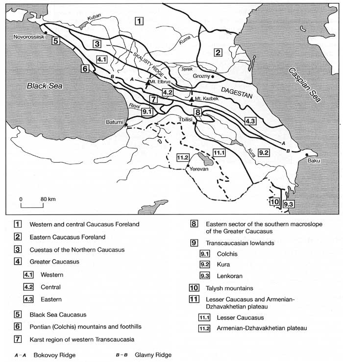
Fig. 15.1 Physical-geographical regions of the Caucasus
Each of the Caucasian provinces has a distinct character formed under the influence of
the neighbouring territories. The northern foothills of the Greater Caucasus have much in
common with the steppes of the East European plain; environments of the Black Sea region
have been affected by the Mediterranean; while in the eastern Caucasus and Transcaucasia
the influence of Asia Minor is apparent. The mountains, especially the Greater Caucasus,
predetermine the development of distinct climatic and biotic gradients, both vertical and
horizontal, and form a natural barrier that limits the migration of species and provides a
variety of habitats. These factors have resulted in a unique nature of each of the
physical-geographical regions.
The Caucasus belongs to the middle sector of the Alpine-Himalayan mountainous belt that
was created by continental collision between the Arabian and Eurasian Plates. In
geological terms, the Caucasus is a very young region: its evolution began in the Mesozoic
at the active margin of the Tethys Ocean while the uplift of the Greater Caucasus is dated
to the Miocene (Philip et al., 1989; Zonenshain et al., 1990). The main features of the
continental collision are the northwards drift of the Arabian Plate, the lateral ejection
of the Anatolian Plate to the west, and the Iranian Plate to the east. The convergence of
the Arabian Plate and Eurasia created the Lesser Caucasus which, being pushed to the north
by the Arabian Plate, stamped against the continental crust and initiated the development
of the Greater Caucasus (Philip et al., 1989). Over a few million years of its history the
Caucasus has experienced a dramatic transformation from a marine basin and lowlands to
mountain ranges exceeding 4000 m in altitude. In the eastern Greater Caucasus, ancient
coastal cliffs are found at an altitude of 3500 m, with marine sediments of late Miocene
age preserved on the adjacent shore platform (Budagov, 1964). Periods of accelerated plate
convergence resulted in episodes of enhanced mountain building, nappe formation, and
volcanism. A major structural unit, the Greater Caucasus is constituted by nappes thrust
in a meridional direction and currently its eastern sector is the region in continental
collision while the western part shows some features of the former subduction. Only
recently was the Caucasus a scene for intense volcanic activity: the Armenian highland was
flooded by calc-alkaline basalts and andesites in the Pliocene and the highest summits of
the Caucasus, the Elbrus, and the Kazbek, formed as Pleistocene-Pliocene volcanoes. The
Kazbek is no longer active, but the Elbrus erupted in postglacial times and fumarole
activity is registered near its summit (Mazurenkov and Panteleev, 1962). Contemporary
seismic activity is a prominent feature of the region, reflecting active faulting and
crustal shortening. Clusters of seismisity occur in Dagestan and in northern Armenia
(Philip et al, 1989). Many devastating earthquakes have been documented in historical
times, including the Spitak earthquake in December 1988 which destroyed the Leninakan (now
Gyumri)-Kirovakan region of Armenia.
The tectonics and geology of the Caucasus have been the subject of extensive research
and many reviews have been published in English including those by Khain (1975), Adamia et
al. (1977), Zonenshain and Le Pichon (1986), Gamkrelidze (1986), Philip et al. (1989), and
Zonenshain et al. (1990).
This chapter begins with a brief description of the main regions of the Caucasus and
proceeds with analyses of climate, glaciation, environmental history, and modern
vegetation. Note that the transliteration of geographical names, used in this chapter, may
differ from that used by other authors.
<<< The Mountains of Southern Siberia:
Stanovoy and the Dzhugdzhur Ridges | Biomes & Regions Index
| Physical Geographical Regions of the Caucasus and Transcaucasia
>>>
Contents of the Caucasus section:
Other sections of Biomes & Regions:
|
|


