Please put an active hyperlink to our site (www.rusnature.info) when you copy the materials from this page
Biomes and Regions of Northern Eurasia
Arid Environments
<<< Litho-edaphic Types of Central Asian
Deserts | Biomes & Regions Index | Biota and Soils >>>
Geological Structures and Major Characteristics of Relief
Landform Systems and Paleogeography
The landforms of the Central Asian deserts feature distinctive relationships with their
geological structure. These relationships, however, are much more complex than simple
structural inheritance. The Neogene-Pleistocene continental and marine deposits form the
major part of the Turanian plain. Their thickness attains 4000 m (Geller and Rantsman,
1968; Babaev, 1996). According to their genesis and hypsometric conditions, sharply
distinguished levels may be identified on the plains of Central Asia. Loose sandy deposits
mainly form the first one, with elevations ranging between 130 m b.m.s.l. and 200 m. In
the south, south-east, and east it is surrounded by piedmont plains. The second, higher
level, with elevations ranging between 200 m and 400 m, comprises the Ustyurt plateau and
adjoining uplands (e.g., Krasnovodsk and Mangyshlak) and is formed by the Mesozoic and
Tertiary marine deposits. The data from deep drill cores show the presence of
post-Jurassic sedimentary rocks. During the upper Paleozoic and also during the Mesozoic
this area experienced active tectonic movements, which resulted in intensive erosion,
transportation, and accumulation of material.
During the Paleocene increasing tectonic activity progressively transformed the
landforms. The second half of the Paleocene featured very active formation of folds in the
southern part of the Turanian plain (Geller, 1968). Since that time the major part of
Central Asia has entered a phase of continental sedimentation. An exception is the western
part of the area, which was occupied by Neogene and then Quaternary bays of enclosed sea
basins that constantly changed their level and configuration (Varuschenko et al., 1987;
Babaev, 1996).
The rise of the Pamir-Alay mountains resulted in formation of river valleys, which now
cross the plains of Central Asia (e.g., the Zeravshan, Syrdarya, Amudarya, Chu). The
formation of the Transunghuz desert dates back to the Pliocene epoch, or more precisely to
the period between the late Sarmat and Pont, according to the paleo-graphic stratification
of the Caspian Sea. The Neogene-Paleogene alluvium of the Amudarya was a principal source
of redeposited material in this region. The granulometric composition of these strata is
very similar to the present-day alluvium of the upper course of the Amudarya. The river
sediments alternate in some places, especially in the western part of the Transunghuz,
with lake sediments typical of alluvial plains. The lower part of the Transunghuz stratum
is dominated by non-redeposited alluvium (Babaev, 1996).
According to much paleogeographic evidence, the Central Asian plains were dominated by
dry and continental climatic conditions during the entire Cenozoic. Vertical tectonic
movements in the middle Pliocene created boundaries of the major desert regions, which
were similar to those of the present. During the phase of the simultaneous accumulation of
aeolian sand strata, the upper Neogene deposits were gradually separated in many places
(Geller and Rantsman, 1968). Deep drilling has disclosed valley-like depressions, which
had resulted from the ancient temporary inflowing streams (Babaev, 1996). Their extremely
non-uniform depth along their longitudinal profiles, however, suggests that these
longitudinal valley-like depressions, similar to the Unghuz valley, should be regarded as
channels resulting from very short temporary runoff rather than as paleo-river valleys.
The continental Pliocene and Pleistocene deposits extend over almost the entire
territory of the Central Asian deserts and are represented by diverse genetic types. They
include the pre-Amudarya river deposits dating from Paleocene to Pleistocene, the Murgab
and Tedjen Neogene and Quaternary deltas, the upper Pleistocene alluvium of Afghan rivers
and the Sarakamysh, and Aral late Quaternary and Holocene deltas of the Amudarya and
Syrdarya rivers (Babaev, 1996).
During the late Pliocene and early and middle Pleistocene the main factors introduced
in the sediment accumulation and relief formation were fluvial erosion and accumulation.
The young river systems starting in the mountains cut deep valleys across the piedmont
plains. Later, these valleys were filled and covered with thick alluvial sediments over a
large zone along the mountain slopes of the Kopetdagh and Parapamiz.
The Pleistocene deposits of the Karakum and Kyzylkum accumulated predominantly under
dry climatic conditions. During the warmer periods of intensive melting of the glaciers in
the mountains, large wandering river systems were fed by the increased flow of water from
the mountain slopes. The erosion processes were especially active on the piedmont plains,
where poorly cemented sandstones and loess-like loams were extensively washed out by
occasional streams and then further reworked by wind erosion. Marine deposits are present
only in the western part of the Lower Karakum desert. Here, apart from the Pliocene
deposits, there are also the Pleistocene deposits corresponding to the Apsheron, Baku, and
Khazar transgressions of the Caspian Sea of the early and middle Pleistocene, and to the
most extensive Khvalynian transgression of the late Pleistocene (Varuschenko et al.,
1986).
Surface Deposits and Processes
The geomorphological systems of Central Asia comprise low and high plains of various
origins and ages as well as the relict mountains (inselbergs) and piedmonts of surrounding
high mountain systems.
Most of the sandy deserts of this area can be classified as aeolian-alluvial sands
(e.g., the Karakum, Kyzylkum, and Muyunkum) (Figure 12.4).
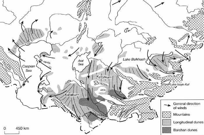
Fig. 12.4 Aeolian relief in the deserts of Central Asia and Kazakhstan.
Modified from Fedorovich (1948)
Their less widespread variety — Aeolian-deltaic sands — are restricted to the
ancient deltas of rivers, which flowed into the Aral and Caspian Seas and Lake Balkhash.
They are distinguished by better sorting and a large admixture of very fine particles
(Petrov, 1976). Aeolian-alluvial sands are restricted to the piedmont plains. They are
poorly sorted and often enriched with pebbles and gravel showing signs of aeolian
weathering. Aeolian-sea coast and lakeshore sands are the result of the winnowing of sand
deposits during their desiccation. They form the coastal dunes of the eastern Caspian and
the Aral coasts. They are usually medium- and coarse-grained and not very well sorted.
All these genetic types of aeolian sands were formed in situ by the winnowing of loose
sand deposits (parent material) and are therefore called 'authigenic' (Sidorenko, 1961;
Petrov, 1976). In contrast, the aeolian sands of stony structural plains consisting of
pre-Quaternary sandstones (e.g., the Ustyurt plateau) are mainly formed by the
introduction of wind-borne sands from elsewhere and only partly by deflation of the
underlying conglomerates and other stony bedrocks. They are termed 'allogenic'
(wind-borne).
Despite some variations in the relief of the Central Asian sandy deserts, longitudinal
dune ridges are dominant, but only some of them are entirely aeolian in origin. In many
regions of the Karakum desert, the dune ridges were shaped by alluvial processes in the
Pleistocene and Holocene and then were partly reworked by aeolian processes (Geller and
Rantsman, 1968). Meteorological observations carried out since the beginning of the 20th
century in the Lower Karakum indicate a rather complex wind regime, with a dominance of
westerly, north-westerly and north-easterly winds. This region, however, is characterized
by dune ridges that extend along the meridian (Figure 12.4). Most sand ridges are
asymmetrical (i.e., one slope is steeper than the other). The ridges themselves are
composed of individual hillocks formed from loose sand deposited around shrubs.
In the Karakum the parallel extension of dune ridges often does not correspond to the
dominant wind direction. Moreover, granulometric analyses of the sands of the Lower and
Transunghuz Karakums showed that the sand particles in the sand dunes are very poorly
rounded except in the top several metres (Sidorenko, 1961; Geller and Rantsman, 1968;
Veysov, 1976; 1988, pers. comm.). According to these authors, aeolian processes have never
affected the major part of the sand material in the Lower Karakum. Also, the structure and
composition of ridges in the southern part of the Karakum contradicts the idea of an
aeolian origin of their formation. Both the kyrs of the Transunghuz, mainly formed by
bedrocks, and typical sand ridges of the Lower Karakum, which contain clay strata in their
profile, could not be formed by aeolian accumulation. Excluding the dominant role of wind,
many authors attribute the relief of longitudinal valleys and ridges to the activity of
fluvial processes. The sand ridges are formed from alluvium, and only their upper stratum
was affected by aeolian activity. At a certain depth, features of aeolian impact
disappear. Thus, the depth of relief dissection of sand ridges is several times higher
than the depth of aeolian influence (Geller and Rantsman, 1968). It is noteworthy that the
ridges of the Karakum are generally perpendicular to the ridges of the Kopetdagh and
Pamirs. Even today, during floods, temporary water streams flowing from the Kopetdagh
slopes penetrate the desert for several dozen kilometres. The Tedjen and Murgab rivers
have reached the Unghuz valley in the recent historical past (Letolle and Mainguet, 1993,
Babaev, 1996). It is very likely that under more humid conditions in the Pliocene and
early Pleistocene, similar flood flows from the mountain slopes could penetrate the desert
for much longer distances. The parallel longitudinal extension of the ridges might be
explained by the fact that temporary flood flows should have a very much higher velocity
than permanent rivers and would follow the direction of their valleys on the mountain
slopes. This is why meandering does not affect the straight, longitudinal form of the
ridge relief of the southern Karakum (Geller and Rantsman, 1968).
However, only the biggest ridges of the southern Karakum have a fluvial origin. Smaller
dunes situated between higher ridges, as well as the longitudinal dunes of other deserts
of Central Asia, are believed to have an aeolian origin.
The barchan fields occur mainly in the delta regions on the eastern coast of the Aral
Sea, along the river banks, and around the oases. If the wind blows continuously in the
same direction the barchan sands can migrate about 5-15 m annually. In the Karakum desert
barchan movement resembles that of a pendulum, with net motion towards the north-west
(around 4-4.7 m annually at Kerki). The barchans develop through several stages:
- (I) regular ripple form;
- (II) these become irregular, as coarser and finer grains segregate;
- (III) symmetric, large undulations develop forming egg-shaped features;
- (IV) the undulations become asymmetrical and take on the shape of barchans;
- (V) true barchans, with steep leeward slopes, form;
- (VI) barchans arrange themselves in pairs or groups; and
- (VII) barchan chains form, perpendicular to the wind direction (Walter and Box, 1983).
Impact of Climatic Change on Desert Landforms
According to much paleogeographic evidence, the formation of desert conditions like
those of the present started in Central Asia with progressive global cooling and aridity
in the early Pleistocene (Varuschenko et al, 1987, Borzenkova, 1992). Climatic variations
through the Pleistocene resulted in multiple shifts from hyper-arid deserts to subhumid
shrublands (Tarasov, 1992, Varuschenko et al, 1987). However, in contrast with some other
desert regions in the world (i.e., the Sahara or Thar deserts), these environmental
changes had relatively small amplitudes so that during the entire Pleistocene the plains
of Central Asia were constantly dominated by dry climatic conditions. The last maximum of
aridity occurred between 20 and 17 Ka BP, followed by an increase of precipitation during
the Lavliakan humid phase. This was synchronous with the New Caspian transgression in the
Holocene (Varuschenko etal, 1987; Kes, 1995).
The landforms of the Central Asian deserts carry relict features both of relatively
short humid intervals with runoff higher than nowadays and long arid phases. The activity
of ancient water flows during the periods of glacier melting in the mountains of Parapamiz
and Tien-Shan left their distinctive traces both on the piedmonts, dissected by deep dry
valleys, and on the aeolian plains, where alluvial fans formed, altering their location at
each stage of alluvial deposition.
The absence of flood and lake deposits in the eastern part of the Karakum results from
the shift of the Amudarya from its ancient valley across the Lower Karakum to its
present-day riverbed. This change was not due to the blocking of river flow caused by a
gradually growing body of sediment, because it occurred rapidly and did not noticeably
affect the composition of the deposits. According to Babaev (1996) it was most probably
caused not by accumulation of alluvium but by tectonic movements resulting in an increase
of erosion. The flat relief of the sandy alluvial plains after the long phase of alluvial
accumulation gradually began to experience weathering and reworking by the wind.
Available paleogeographic, palynological, and archeo-logical data suggest that during
the late Pleistocene and Holocene the alternations of arid and subhumid intervals in this
area were generally synchronous with other desert zones of Asia and North Africa and that
they correlated with global warming and cooling intervals (Borzenkova, 1992, Varuschenko
etal, 1987; Lioubimtseva, 1998). A severe arid phase occurred during the last glacial
maximum (c. 20-18 Ka BP). In Kazakhstan, annual rainfall decreased at that time by not
less than 150-200 mm, mean July temperature was 2°C lower than at present, while the mean
January temperature dropped by 12°C compared to the present (Aubekerov, 1993). According
to pollen data in western Turkmenistan, the mean annual temperature decreased by 4.5°C
(Kes et al., 1993). Such climatic conditions intensified aeolian activity and loess
accumulation (Liu et al., 1995). According to the latest research of Dodonov (1997, pers.
comm.), intensive processes of loess accumulation (more than 0.3 mm per year) also
occurred in southern Uzbekistan and Tajikistan. Cool desert conditions also resulted in
very low levels of the Caspian and Aral Seas. In the history of the Caspian Sea, the
interval between 25 and 16 Ka BP, known as the Yanotaevsk regression, saw sea level drop
to 64 m b.m.s.l., and for a short period, even to 135 m b.m.s.l. (Varuschenko et al.,
1987; Golubev, 1998).
The middle Holocene global optimum caused a significant increase of precipitation in
many desert regions of the world. In Central Asia, the Holocene climatic optimum is known
as the Lavliakan humid phase and has been dated in different archeological sites from 8 to
4 Ka BP, with a maximum around 6.5 Ka BP (Mamedov, 1990). Such climatic conditions
favoured the development of Artemisia and Gramineae steppes on the currently lifeless
plateaux of the Caspian-Aral watershed. In the Holocene history of the Caspian Sea, three
transgressive intervals correspond to the optimal conditions in its basin: 8-6 Ka, 6.4-5.4
Ka, and 4.3-4.1 Ka with maximum sea levels of: 16.5-22, 18.5-28, and 18-22 m b.m.s.l.,
respectively (Varuschenko et al., 1987).
According to available pollen data in northern and eastern Kazakhstan, the dry cold
steppes of the Younger Dryas were replaced in the Holocene by more moisture-demanding
forest-steppe vegetation with a maximum increase of arborescent species (Aubekerov, 1993;
Tarasov, 1992). These changes in precipitation and vegetation cover resulted in a decrease
of erosion and favoured soil accumulation processes.
Inflowing Rivers
Inflowing rivers crossing the deserts of Central Asia play a key role in the
hydrological system of this area.
The Amudarya results from the confluence of the Pyandzh and Vaksh rivers in the Pamir
mountains at an altitude of 4900 m (Letolle and Mainguet, 1993). Its entire length,
including its main tributary, is 2540 km. Its active basin covers about 309 000 km2.
It collects water from four main tributaries: the Kyzyl-Sou, Vaksh, Kafirnigan, and
Sourkhandarya rivers. The Amudarya transports a considerable amount of clay and sand
particles (from 1 to 3.5 kg m-3), which is the second biggest river sediment
discharge in the world after the discharge of the Huangh in China (Letolle and Mainguet,
1993). The formation of the pre-Amudarya valley resulted from the uplift of the alpine
system, when the south edge of the present desert area began to rise. The pre-Amudarya
carried an enormous amount of suspended material. It has deposited a stratum of alluvial
sand and clay whose current thickness attains about 600m.
Paleo-evidence suggests that the Zeravshan ran into the Amudarya in historic times.
Today, the Zeravshan, 870 km long, ceases to flow in the desert after nourishing numerous
irrigation canals around Bukhara and Samarkand and giving part of its water to the
Amudarya via a canal near Bukhara. According to paleogeographic data the Zeravshan river
valley was formed much earlier than most other Turanian river valleys and has never
experienced considerable changes (Babaev, 1996).
On the other hand, the Syrdarya became a single artery only at the beginning of the
Pleistocene, as a result of the combination of multiple smaller river systems of separate
drainage areas on the mountain slopes. The same is true for the Chu, which formed from a
number of closed river systems into a single river artery only in the Pleistocene. Today,
the Syrdarya is 2212 km long, or 3019 km with its tributary — the Naryn. Its basin
comprises more than 219 000 km2 (Letolle and Mainguet, 1993). The only
important tributary that the Syrdarya receives on the plain is the Chirchik. The latter is
only 160 km long but has a flow of 224 m3 s-1 descending from the
mountains.
The Chu, 1400 km long, starts from the glacier in the Terskey-Alatau and, crossing the
sands of the Muyunkum deserts, loses itself in a series of small lakes (e.g., the Akzaikin
and Aschikol), before finally flowing into the small Terekol Lake together with another
desert river — the Sarysu.
<<< Litho-edaphic Types of Central Asian
Deserts | Biomes & Regions Index | Biota and Soils >>>
Contents of the Arid Environments
section:
Other sections of Biomes & Regions:
|
|


