Please put an active hyperlink to our site (www.rusnature.info) when you copy the materials from this page
Biomes and Regions of Northern Eurasia
The Far East
<<< The Maritime Province | Biomes & Regions Index | Kamchatka
>>>
Sakhalin
The island of Sakhalin extends along the Pacific coast for 950 km (Figure 18.1).
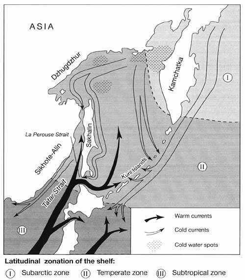
Fig. 18.1 A sketch map of the Far East
With an area of 76.4 thousand km2, it is Russia's largest island. In terms
of tectonics, Sakhalin is a part of the Sikhote-Alin — Sakhalin fold belt and is
separated from the Sikhote-Alin by the Tatar Strait trough and the West Sakhalin trough.
The formation of the Sakhalin island arc can be dated to the early Miocene since the
calcalcaline volcanic rocks of Miocene age are found in abundance in the West Sakhalin
mountains (Zonenshain et al, 1990). At the end of the late Pleistocene, Sakhalin was
connected with the mainland and the island of Hokkaido by land bridges (Figure 18.3).
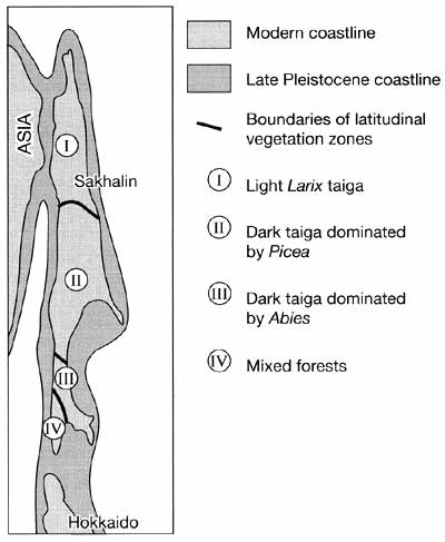
Fig. 18.3 Coastline and latitudinal vegetation zones in Sakhalin
A clear indication of this connection is the occurrence of dunes of aeolian origin in
the north-west of the island. The dune chains extend along the Sea of Japan coast for
about 250 km continuing into the Tatar Strait and the Sea of Okhotsk shelf (Korotky,
1993). A late glacial transgression, which began 17-18 Ka BP and proceeded rapidly at a
rate of 9 m per 1000 years, has led to its isolation (Aleksandrova, 1982). At present, an
8 km wide Tatar Strait separates Sakhalin from the mainland in the north-west while
Hokkaido is located 42 km southwards. The continuing uplift of the island (which is more
rapid in its middle part) results in high seismic activity with earthquakes reaching 8
points on the Richter scale (Geology and Mineral Resources of Japan, 1977; Leith, 1995).
Geomorphology and Environmental History
The northern sector of the island is flat while mountainous relief is characteristic of
the southern part and accounts for about 70 per cent of the total area. Although absolute
heights are low, the Sakhalin mountains have steep dissected slopes and their development
is difficult. There are three main tectonic and orographic elements extending in a
submeridional direction in the southern part (Aleksandrov, 1973):
1. The main structural feature of the island is the Central Sakhalin graben, which
extends longitudinally through the whole island and farther into Hokkaido, separating the
West Sakhalin mountains and the East Sakhalin mountains. The graben is filled with thick
(2-8 km) unconsolidated Neogene-Quaternary deposits. A chain of lowlands corresponds to
the graben of which the Tym-Poronay lowland is the largest.
2. The East Sakhalin mountains, extending from approximately 49 to 52°N, are composed
of strongly dislocated metamorphic pre-Cretaceous rocks. Folding and thrusting occurred at
the Creataceous-Paleogene boundary. Paleogene strata overlie the nappes and the folded
structures are cut by intrusions of biotitic granites and granitodiorites with an isotopic
age of 58-66 Ma (Zonenshain et al, 1990). The ridges, broken by grabens of various ages
filled by alluvial and fluvioglacial deposits in the early Pleistocene, are distinguished
by non-structural erosional relief with numerous planation surfaces.
3. The West Sakhalin mountains formed in the late Pliocene-early Quaternary when the
rocks of the West Sakhalin trough were thrust over unconsolidated deposits of the
Tym-Poronay depression. Typical of the West Sakhalin mountains is structural denudational
relief which developed as a result of selective erosion under the neotectonic conditions
and changes in sea level. Although it is tectonic uplift which is primarily responsible
for the deep river incision, a decline in sea level of 110-130 m, which occurred during
the Pleistocene climatic minimum of 18-20 Ka BP (Korotky, 1993), contributed to the
formation of rugged topography. While absolute heights vary between 300 m and 1300 m, deep
intermontane depressions and river valleys are typical.
The plains and low hills of northern Sakhalin are composed of gently inclined folded
Neogene strata and are shaped by abrasion and denudation (Kulikov et al, 1993). The
depressions located in its central part are filled with unconsolidated Quaternary deposits
mainly of alluvial and, less often, marine origin. The lacustrine-alluvial and marine
accumulative plains occupy coastal areas. Most of the western coast has abrasional relief
with cliffs reaching 8-10 m in the north and 60-80 m in the south. At present, the western
coast has completed its abrasional-accumulative cycle and has reached a stage of dynamic
stability (Kaplin et al., 1991).
Ecology
The cold and humid climate of Sakhalin (annual precipitation ranges between 600 mm and
1200 mm; winter temperatures range between 10°C and 24°C below zero and summer
temperatures do not exceed 13-15°C), resulting from monsoonal circulation and the cold
Sea of Okhotsk waters which carry floating ice even in summer, predetermines the
development of boreal landscapes across most of the island despite its location between
54°N and 46°N. While taiga, bogs, and coastal meadows develop in Sakhalin,
forest-steppe, steppe and semi-desert biomes occur at the same latitudes in the East
European plain. Only south-western Sakhalin has more favourable climatic conditions due to
the ameliorating influence of the warm Tsushima current which predetermines the
development of rich and distinctive vegetation. There are two main models of vegetation
zonation. According to the earlier model, which dates back to the USSR Geobotanical
Zonation Scheme published in 1947, Sakhalin belongs to the Eurasian zone of coniferous
forests which is represented by Larix forests in the north and Abies-Picea taiga in the
south. A later scheme recognizes four geobotanical entities (Figure 18.3): the light Larix
taiga, the dark taiga dominated by Picea, the dark taiga dominated by Abies, and mixed
dark-coniferous and broad-leaved deciduous forests (Geografla Sakhalinskoy oblasti, 1992).
The subzone of larch taiga is represented by swampy open woodlands formed by Larix
ochotensis with an admixture of Pinus pumila, Alnaster maximowiczii, Betula middendorfii,
and B. exilis which intermingle with shrub-lands of Pinus pumila and sphagnum bogs. Picea
forests develop in the better-drained uplands.
The dark Picea taiga formed by Picea glehnii, P. ajanensis, and Abies sachalinensis
develops in the mountainous areas of the middle Sakhalin while in the valleys forests are
formed by small-leaved deciduous species (e.g., Betula, Alnus, Salix, Populus, and
Chosenia) and locally by heat-loving broad-leaved species (e.g., Quercus mongolica, Ilex
rugosa, Ulmus ladniata, and Acer mono) (Manko, 1967; Ageenko et al., 1973). Vertical
zonality is well-marked in the East Sakhalin and West Sakhalin mountains (Tolmachev, 1956;
Ogureeva, 1999), (Figure 18.4).

Fig. 18.4 A combined model of vertical vegetation zonation in the West
Sakhalin and East Sakhalin mountains. Data from Ogureeva (1999)
South of 48°N, forests dominated by Abies sachalinensis with an admixture of Picea
ajanensis, P. glehnii, and broad-leaved species, especially Quercus mongolica, prevail.
The participation of southern species is notable and tree and shrub floras are enriched
with such species as Viburnum furcatum, Aralia schmidtii, and Ilex crenata. Bamboo (Sasa
kurilensis) forms dense undergrowth in forests as well as thick thickets in non-forested
locations. Tall-grass meadows of a simple floristic composition, comprised mainly of such
species as Polygonum sachalinensis and Cardiocrinum glehnii, are also typical of this part
of the island.
The most unusual and rich vegetation develops in the south-west of Sakhalin. There are
relatively few endemics (about a hundred out of 1500 species found on the island including
Eupatorium sachalinense, Viburnum wrightii, and Polygonum sachalinensis) because Sakhalin
became isolated from the mainland only recently. Rather, the specific character of the
vegetation is manifested in the combination of boreal and southern species, and also in
the development of gigantism, which is a very prominent feature. The mixed broad-leaved
coniferous forests contain many Manchurian and Japanese woody species, vines, and bamboo.
Such southern species as Phellodendron sachalinense, Quercus crispula, Kalopanax
septemlobus, and Toxicodendron orientale grow alongside Picea and Abies. The development
of gigantism in woody and herbaceous plants is predetermined by an optimal combination of
heat and moisture as well as the fertilizing effect of sea salts and the abundance of
microelements in the soil due to recent volcanic activity (Morozov and Belaya, 1988;
Morozov, 1994). In riparian habitats, these factors are enhanced by the high contents of
phosphorus and nitrogen in the soil which is due to the decomposition of fish that enter
the rivers to spawn and die. Plants attain lavish growth: in riparian habitats Chosenia
macrolepis reaches 25 m in height and Populus maximowiczii attains 8 m in cicumference.
Herbaceous plants, such as ferns (Struthiopterisfilicastrum), umbellates (Angelophyllium
ursinum and Heradeum barbatum), Cacalia hastata, Senecio cannabifolius, and Filipendula
kamtschatica, attain 2-3 m in height. Such vegetation communities are unique and apart
from Sakhalin occur only in the southern Kurils and northern Hokkaido. The primary
vegetation of southern Sakhalin has been extensively damaged by fellings and fires.
Secondary communities are formed by forests of Betula ermanii, bamboo thickets, and
meadows and there is no clear vertical zonation in the mountains of southern Sakhalin.
Environmental Management and Conservation
With a population of 650 000 Sakhalin remains relatively undeveloped. Coal mining, the
production of gas and oil, timber industry and fisheries are the major industrial
activities, while agricultural lands (excluding reindeer pastures) cover just above 1 per
cent of the territory. However, general statistics conceal some important regional
differences. While in northern Sakhalin reindeer herding is the main occupation outside
the rapidly growing gas and oil production, the middle and southern parts of the island
are under much greater anthropogenic pressure. The timber industry dominates middle
Sakhalin producing about 3 million m3 of wood per annum and targeting
coniferous forests which have an important protective role with regard to soil erosion and
maintenance of the healthy spawning grounds (Sakhalinskaya oblast, 1994). In many areas,
timber resources have already been exhausted and yet production continues across the
region, reducing coniferous forests by 15-19 ha a-1. These rates are
unsustainable given the lack of reforestation efforts and slow natural regeneration which
is impeded by such fast-growing species as tall grasses and bamboo. About 70 per cent of
all the Sakhalin population is concentrated in the coastal zone and plains of southern
Sakhalin which account for about 20 per cent of the total area. This region has the
longest history of development which dates back to the mid-19th century, focusing on coal
mining. Accounting for about a half of the total industrial and agricultural output, this
part of the island is under the strongest anthropogenic pressure. The development of major
offshore gas and oil reserves may prove a mixed blessing for the island. The Sakhalin
shelf contains rich deposits of high quality hydrocarbons which may provide the region
with economic and energy security and political benefits (Shelf Sakhalina, 1975; Paik,
1995). However, many environmental scientists and activists express their concern about
the potential impact of high seismic activity (Tkalin, 1993). Although environmental
impact assessment was conducted at the beginning of 1997 and the project incorporates
protective measures, doubts over safety remain given the sad history of inadequate
implementation of such measures in Russia.
<<< The Maritime Province | Biomes & Regions Index | Kamchatka
>>>
Contents of the Far East section:
Other sections of Biomes & Regions:
|
|


