Please put an active hyperlink to our site (www.rusnature.info) when you copy the materials from this page
Russian Zapovedniks and National Parks
<<< Zapovednik "Vitimsky" | Index and Map | National Park
"Alkhanay" >>>
Zapovednik "Ubsunurskaya Kotlovina"
Address: 667007 Republic Tyva, Kyzhyl, Komsomolskaya St., 122.
Zapovednik Ubsunurskaya Kotlovina is situated on the southern edges of the Republic of
Tyva within the Erzinsky, Tes-Khemsky and Mangut-Taiginsky Districts. The Zapovednik was
founded in 1993. Its area is 39,6 thousand ha.
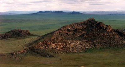
The Zapovednik as located to the south of Tyva on the border with Mongolia. It consists
of five parts.
1) Tsugeer-Els (4900 ha) — valleys with an average height of 1000-1200 m above sea
level. Plant cover is feather grass or decertified steppes.
2) Yamadlyg (800 ha) — steppe plant cover is more developed. There are more than 300
barrows, ancient graves.
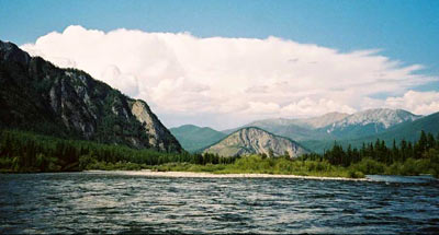
3) Ular (18 thousand ha), in the basin of the Ular-Khem River on the southern side of
Mnt. Sangilen. This is a mid-size mountain District (1400-2200 m above sea level) with
well expressed height belts in its plant cover: mountain-taiga forests, replaced higher up
by mountain steppes and high-mountain meadows.
4) Mongun-Taiga (940 ha) — a granite massif with alpine relief and a young glacier.
There are high-mountainous plants of a Central-Asian type (alpine meadows, tundra, and
cold steppes).
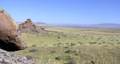
5) Aryskannyg (15 thousand ha), the southern slopes of the ridge of Vostochny Tannu-Ola
at 2200-2300 m above sea level. Light larch-cedar and larch grass forests, rocky desert
steppes. On the flat watersheds rocky dwarf tundras are developed, while in the valleys
are dry and decertified steppes.
From zoogeographical point of view Ubsunurskaya hollow is characterized by a unique
combination of desert (Chlamydotis undulata, desert wheatear, midday gerbil, hairy-footed
jerboa), steppe (Melanocorypha mongolica, Cricetulus barabensis, and Ochotona daurica),
taiga (three-toed woodpecker, nutcracker, Tetrao urogalloides, chipmunk and flying
squirrel) types of fauna.
The diversity of Landscape, and interchanging of forest and steppe sites on mountain
slopes are very favorable for the Siberian form of deer — the maral — that is numerous
here.
Historical monuments of ancient people are very diverse; with barrows, stone
sculptures, and wall paintings and drawings.
The Zapovednik has biosphere status.
<<< Zapovednik "Vitimsky" | Index and Map | National Park
"Alkhanay" >>>
|


